Monday, 26 January 2015

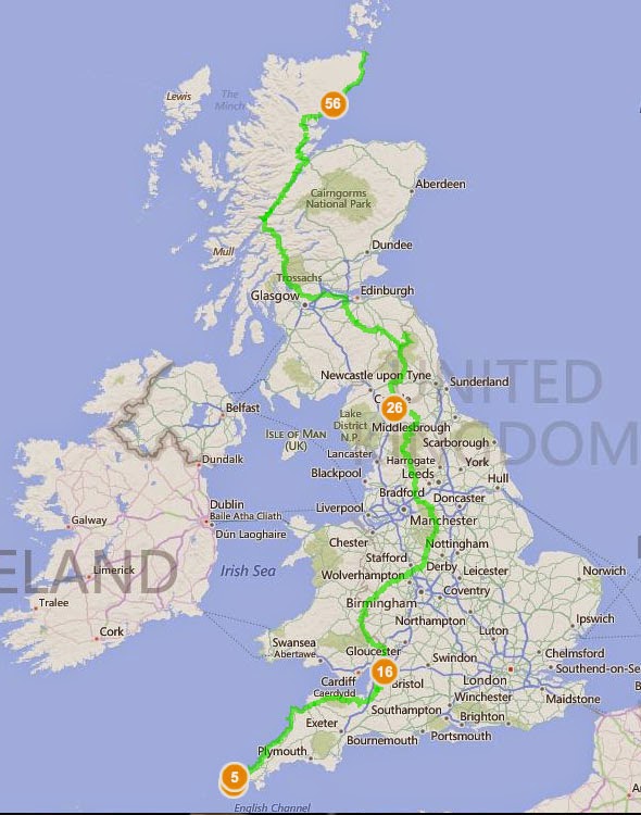
End to End - Lands End to O'Groats on Foot, Route planned on Bing's Free Ordnance Survey Maps

http://www.bing.com/maps/?v=2&cp=52.952792~-3.075215&lvl=7.06&sty=s&cid=EB5023FD3693F27!220&form=LMLTEW
                     CLICK ON THE MAP AND ZOOM TO SEE THE ORDNANCE SURVEY MAPS

View Larger Map  |  Get Directions  |  View Bird's Eye

Possible route from Lands End to O'Groats on Foot. Just spent the last three days plotting it across Bings Ordnance Survey Maps- did you know they had them free across the whole of England!!!! This has definitely earned them my love.
Does anyone know an easy way to avoid trudging up the A roads at the end? I'm trying to navigate a different route but I suspect it'll be me lost in moor land swearing and daydreaming about passing cars and tarmac. 
  Over the next few weeks I'll be breaking down the walk into smaller sections and playing around with possible alternatives but I wanted to get a better idea of the distances and terrain first. Boy is it daunting. Any advice PLEASE email.

  Route tracked a mixture of Andy Robinson's route in 'The End to End Trail' (books bloody heavy, no way I'd carry that with me and the maps are a little confusing but it is helpful) and  'When I Walk, I Bounce: Walking from Land's End to John o'Groats ' by Mark Maxon (personal account of the walk, not guide, but funny and engaging)

This route partly goes along the following National Trails:

South West Coastal Path
Offa's Dyke Path
Pennine Way
West Highland Way
Great Glenn Trail 

I've partly chosen it because it covers half of Offa's Dyke instead of remaining more central and walking up the Cotswold Way. I've done the majority of the Cotswold Way already and find open moors more more appealing than a long stream of golf courses.

DISCLAIMER - other peoples routes and I've yet to walk them. All this is is a very carefully plotted trail based on their instructions.

Friday, 23 January 2015

50 Miles Along the Cotswold Way

Day 1- Chipping Campden to Hailes (16 Miles)

 
  I'd stayed in Stratford-upon-Avon last night, in a hostel, worrying about this morning. The hour it had taken me to walk between the center of town and the hostel has pulled something in my back. Such a wimp so early in the walk. Then next day I wondered back into town, caught a bus and made my way to Chipping Campden and the start of the Cotswold Way. 
  I passed through Chipping Campden quickly, patting the sign on the Town Hall which marks the beginning or the end of the hike. The town is dates back to the 14th 15th Century, the home of the successful wool merchant William Grevel. Rather fitting for me, an artist, that I set off from a town where Arts and Crafts helped save this town from decline after years of agricultural doldrums.The gravel path rises up into the hills, past a farm or two and towards Dover's Hillat 225 Meters.
  The land here seems straight from Milton's Jerusalem Hymn by William Blake:

And did those feet in ancient time
Walk upon England's mountains green?
And was the holy Lamb of God
On England's pleasant pastures seen? 


 Approaching Broadway Tower


  The climb, quite gentle in nature, takes you up to Broadway Tower, a very fine looking building from 1799 for Lady Coventry by the 6th Earl of Coventry. Its on Beacon Hill 312 Miles above sea level and the second highest point on the Cotswold Way. Its then straight down over farm fields to Broadway. Broadway is a lovely town, bustling with people and little privately owned cafes. I stopped and bought myself an orange, found a bench and stopped for lunch. A perched pigeon promptly pooed on my brand new shorts on the branch above.
 

  I met another hiker later on that day and attempting to match his pace we walked together the rest of the way indulging in a quite wonderfully nerdy debate on equipment, walking boots and other walks we'd been on. I know no other hikers and been able to go on like this was quite a treat. He was a much more experienced hiker, on his way to completing all the national trails in England. Not that I'd confess it out loud but I was walking faster than I had before and I felt it the next day. I got into camp so much earlier though and lay around reading and eating grapes that I'd bought from farm shop, resting my limbs and enjoying the unexpected warm of the Spring sun. 


Thursday, 22 January 2015

Gear Review - Scarpa Ranger II ActTX Womens Walking Boots


 Bought - May 2013 
Distance - 300 Miles
 Price - 160.00
  Shoe Size - 7 

PROS

  As advertised they are waterproof and insulating, protecting you from the path with impressively thick and hard soles. These boots are hard and built to last. They look like they've been taken a strolls over the fields not 300 miles over moor land, through marshlands and gravel lanes and roads. Scarpa boots are designed to survive pretty much everything. The only problem is my feet might not survive them over the course of another walk.


 CONS

    I bought these in preparation for the Pennine Way. They are heavy boots, the ankles cushioned and very well padded fixing your foot in place. They advertise that "Auto-fit foam inserts in heel area provide perfect foot hold and increased comfort" and for the first twenty miles this is fine, and while they aren't as cushy as they appear in the shop they seem fit for the job. By the fortieth mile however things go down hill. First its important to note that I have wide feet and not dainty skinny ankles. I suspect shoes are like a kiss and its not about how skilled one person is but how they fit together. These boots and I were never meant to be. For the entire Pennine Way, 250 Miles, they game me hell blistered my left heel and compressed it so that it could hardly carry any weight. I only carried on my heavily plastering it and wearing a supportive bandage. I assumed I'd just not broken them in enough, that my feet had just not hardened to the trail, but since then I've come to realize that it wasn't me it what the boots. On the Cotswold Way, a 100 mile walk, they'd given me five blisters on one foot and three on the other by the second day, and soon after my heel began to hurt for the first time since the Pennines. I've concluded that the constraints around the heel compressed my ankle too much, as my feet were simply too wide. Even if they did fit well its also worth noting just how heavy these boots are, and once they're wet they drag.

Upper Material: Leather
Waterproof: Yes
Waterproof Technology: GORE-TEX®
Height: Boot Cut
Insole: Viscoflex Activ fit insole with memory foam
Midsole: Hi-Flex
Sole Type: Vibram®
Stiffness: Soft, for low level walks on defined trials
Lacing Type: Standard Lace Up
Boot Grade: B0 - not suitable for crampons
Ideal Crampon Rating: Not Crampon Compatible

 
CONCLUSION

   I wouldn't buy another Scarpa boot. In fact I took quite a lot of pleasure in selling them on ebay and using the money to buy myself a forty pound pair of Trespass walking boots. These Trespass boots are light, waterproof and an instant match. I took them on a thirty mile hike and didn't get a single blister. I hated how heavy Scarpa boots were, hated putting them on in the morning and there are simply not enough plasters in the world to make them comfortable.

Wednesday, 21 January 2015

Gear Review - Black Diamond Trail Women's Trekking Poles - Pair


Last day on the Pennine Way, England, during a 28 Mile stint 2013
Bought: November 2012
Miles Covered: 500+ Miles
My height: 5 foot 5  
My Weight : 15 Stone + backpack


Black Diamond Trail Women's Trekking Poles - Pair
  • 3-section poles provide patented FlickLock adjustability and solid, slip-free security
  • Simply flick the lock open, set the length and flick the lock closed—a quick, tight, and easily accomplished task, even with gloved hands
  • Soft, dual-density foam grips and extensions have padded wrist straps for security
  • Poles extend from 23 to 49 in.
  • The Black Diamond Trail trekking poles include low profile baskets for general use and powder baskets for use in the snow
 I found the straps annoying so chopped them off in a fit of ultra-lite hiking verve. Apart from that there's nothing negative to say about them, they support my weight reliably and have never let me down. I'm quite a heavy girl, especially while carrying a backpack and not once did the extensions collapse on themselves and I've barely walked a mile without their help. On a number of occasions I've nearly fallen and placed all my weight on one of them, they bent slightly but held. The handles allow you to grip securely and in varied grips while the textured foam handles prevent you from slipping from sweat.The heights are easily adjustable and show no sign of failing, and make it easy to pack them away once they've been used.There is no shock absorption but I've never felt jarred by them, perhaps this would not be the case if I were walking a long distance on tarmac or concrete.
   I bought these poles because a shop keeper had told me they'd be needed in the Blue Mountains. Before I used them I suspected they were either for the wimpy of elderly but not strong hikers such as I'd be...eventually. Within half an hour of been dropped off on Morton Island I'd changed my mind and relied on them on every hike since in England and Australia. They are essential when crossing difficult or slippy land, they are also very useful in relieving you of some of the weight of the rucksack. They can pull you up a hill and assist when your trying to descend one safely. More that that, when your in Australia or anywhere else that's inhabited with poisonous snakes, they provide a barrier and protected obstruction which might make all the difference on either side of your legs.As for picking up a stick from the bush instead...why would you when both poles together weight only 1oz and can be packed away when not needed?

Descending down into the valley in the Blue Mountains 2013
SpecificationDescription
Best useHiking
Shaft materialAluminum
Grip materialFoam
AdjustableYes
Maximum length (in.)49 inches
Minimum length (in.)23 inches
Maximum length (cm)125 centimeters
Minimum length (cm)59 centimeters
Locking mechanismExternal lever lock
Shock absorbingNo
Camera mountNo
Weight per pair1 lb. 1 oz.
GenderWomen's


Crossing a shallow creeks in the Australian bush 2012


Gear Review - BlackWolf Mantis 1 Person Hiking Adventure Tent

On the first campsite along the 6 Foot Track in the Blue Mountains, Australia 2013
Tent in the middle of the Australian Outback, along the Sunshine Hinterland 2012


The Lizard, Cornwall, England 2013


RRP $269.00

Large ViewSleeps: 1
Dimensions: 255 x 220 x 80cm
Weight: 1.9kg
Floor: Polyester 5000 PU coating
Fly: Ripstop polyester 3000mm water column
Poles: (2) 8.5mm premium T6 alloy 
Features:

  • 2-pole tapered rectangular design
  • Spacious & lightweight
  • Dual side entry
  • Dual side vestibules
  • Gear hammock
  • Head & foot vents
  • 4 guy rope points
  • Ring ‘n’ pin colour-coded flexi poles
  • Heat taped seams
  • Waterproofpacked size 40cm x Φ15 cm  


Bought: November 2012
Miles Covered: 500+ Miles
Height: 5 foot 5 


Tan Hill, Along the Pennine Way, England 2013
I bought this as my first hiking tent while I was in Australia - since then its sheltered me along the Sunshine Hinterland Great walk (four night- 60 odd kms), Great Ocean Road (six days 100kms), Six Foot Track (3 days 40 odd kms), and god knows how many weekend exertions- one during the floods. Now I'm back from Australia it has braved the considerably less mild weather of rainy England where I've walked the Pennine Way (450 plus kilometers over 15 days along the spine of England into Scotland)- during this trip it rained the majority of the time but sleeping in this tent meant a snug and dry sleep every night no matter what. I've bought a few sets of new tent pegs for it, but other than that it is barely marked. Considering its been put up and taking down every day, stuffed wet back into the rucksack, rolled quickly and badly in winds, and all in all treated quite roughly,  the fact that its in such good order is a testament to just how high quality this tent it. Other basic points- the porch space is very spacious, ventilation is great and although condensation collects on the inside of the tent the material dries very quickly, strong in high winds, no problems with the zips, packs up into a great size, and has WONDERFUL tent poles that seem to magnetically connect together and can almost be flicked into place with your wrist. No sign of the string joining the tent poles snapping. Its quick to assemble if slightly tricky to put up in rain, not high enough to sit up in but material does give a little so that you can move around happily. Be aware that I am a medium to short woman, and a tall man might find this tent somewhat short: my feet do touch the roof but that's because I like plenty of space above my head. As I said this is my first hiking tent so I'm no expert but I can say its been superb every time I've put it up, its durable and has survived me which is something that few other things have managed.  When my friend asked to borrow it I felt she'd asked for my child. I have absolutely no qualms in recommending this tent, its worth every penny been charged.

Devil's Kitchen Campsite along the Great Ocean Walk, Australia 2013
Mankinhole, 3rd Day of the Pennine Way, England

Flaxton Camp Ground, Queensland


Friday, 22 August 2014

Gear Review - The Jetboil Zip Cooking System


  • Drink-through lid with pour spout & strainer
  • Bottom cover doubles as a measuring cup and bowl
  • Compatible with all Jetboil accessories
  • Weight: 12oz (345g)
  • Volume: 27oz (0.8 litre)
  • Boil Time for 16oz (0.5 litre) = 2 minutes, 30 seconds (avg over life of Jetpower canister)
  • Water Boiled: 12 Litres per 100g Jetpower canister
  • Dimensions: 4.1” x 6.5” (104mm x 165mm)

Bought : October 2013 
Cost : £71.95
Meals cooked : 100+   
 PROS

 I've just finished reading 'Wild, From Lost to Found on the Pacific Crest Trail' by Cheryl Strayed and while  I appreciate that it was written about equipment in 1995, descriptions of her stove make me appreciate just how clever this device is. I've so far used it in the monsoon season of Australia, in heavy rain, open moor land, sandy and windy beaches as well as the occasional backyard gardens. It has never faltered, possibly because in its design and manufacture its wonderful simple with very few parts that might go wrong. The materials are light and durable, and easily packed away. The insulation Cargo Cozy on the main cup means that the water heats quickly, and stays warm for a while after which means you use very little fuel. Also allows you to handle it without scorching yourself. On my week long hikes where I cooked at least twice a day I'd end with plenty of fuel left in my 100G cans.  I generally ate straight from the main cup, using the measuring cup to drink out of. When I pack things away they all fit together and I slip the matches or lighter between the heating coils at the bottom, trapping them in with the measuring cup. It means my entire cooking system can fit into the side pocket of your bag weighing only 12 oz, I don't understand why people would bring much else if only cooking for yourself.
  While your restricted to single pan meals there is some leave-way since it brings the water to boil so quickly. I was able to heat water for instant mash which I made in the measuring cup before heating the sauce and pouring it on top. Since the whole operation was completed in ten minutes nothing was too cool by the time I got to eat it.

 CONS

I stopped bringing the locking pot support very quickly as it made packing things away hard and served absalutely no use unless you're bringing another pot, which in turn makes the whole system pointless. That said is allows you to adapt the jet boil to accomodate more if you go on a trip with friends. It is simple enough to leave behind and while it hasn't served me any use at all its cetrainly not ruined the devide.
  The ground stabaliser is also a little tricky and unreliably, which is important when you're cooking in the middle of the dry season in Australia and bush fired are a real danger. Again I must temper my criticism since the twice the stove fell it was at least in equal measure my own stupidity and clumsiness. 
  I remember the first time I used it I found the temperature knob very sensitive and hard to use. Since the cup it insulated its hard to have the hob low enough that the contents is allowed to stew. I found I needed to turn it off once in a while to prevent it overflowing, and then you need unscrew the pan to relight it. When it did occasionally overflow its not simply a pan covered in muck but also the insulating material, and if you have a limited water supply (as in parts of Australia) you want stuff to be as easily washable as possible. The heating system, on the subject of cleaning, is also very tricky. Moreover the lid is black and while it may increase cooking speed makes it impossible to monitor any approaching overflows. I see on their website that they have made the lids see through now which would mediate this problem considerably.

Conclusion
Cooking lunch in the Australian Bush
  I've ended up listing quite a lot of faults but they are all with the accessories, and on the whole the Jet Boil is well worth the money. Its durable and reliable. I don't cook elaborate meals on a trail, in fact I limit myself to ten minutes cooking time, often simply mixing cuscus and stock or soup powder and instant mash. What I need is something to heat water quickly, use only a little fuel and provide me with hot chocolate after. For these uses Jet Boil is wonderful and after using it the idea of bringing pans and plates seems ridiculous. I guess the best test of a product is would you be willing to spend the same again on the product after yours breaks. I most definitely would. 


Tuesday, 20 August 2013

P.W. Day16- Byrness to Kirk Yetholm 28 miles

  Today's walk was the ultimate test of the Pennine Way, the signpost to see if the last two weeks have changed you into a stronger and fitter hiker. Over the 11 to 14 hours of walking ahead of you you'll be climbing over a mile of ascent (1600 meters) with nothing in between Byrness and Kirk Yetholm as a rest bite or creature comfort. I'd told all my friends about this final stretch in a boastful and smug fashion, determined to do it in one or walked till I dropped. 
Looking down towards Byrness
  I was packed up my seven, batteries fully charged and ready. The path back into down is a gentle warm up allowing you're muscles to loosen up before the daily climb back out of the town's valley. Straight across the road you go straight into a heavily wooded area ending in a pretty dicey scramble up the rocky outcrop to Byrness Hill.  


  Instantly your in the middle of nowhere with vast hills and valleys stretching around you. Whats wonderful and daunting at the same time is that the hills seem to have no end yet you're expected to walk them in the next dozen hours. Your path wonders along the ridges, only dipping occationally but mainly following the flow of the landscape across rocky outcrops and peak after peak without a soul insight. A stunning final day was obviously awaiting me.


  Part of my enjoyment was that I knew how much further I had to walk and I wasn't counting down the miles or waiting for the end to come. The weather was spotless and the path easy to follow and without a bog in site. I found myself taking one panoramic photos after another trying to capture within them the sheer vastness around me.
  At one point, nearer the end of the day I spotted a wonderfully dressed gentleman in a twee suit strolling along as if he were the king of the manor. To top it all off he held a open riffle in the crook of his arm. We exchanged pleasantries and he corrected the way I pronounced Kirk Yetholm. Quite charming, in his fifties or sixties.  As we parted I noticed what I took to be an insane man running and hopping in the field on the other side of the fence. As he passed I realized he was actually filming, a massive camera lent on his shoulder.
View from Russell's Cairn
Kings Seat
     I reached the turn point to carry on to the Cheviot and paused unsure whether I was willing to miss the diversion, but not for long. My feet were already starting to cry and my legs felt like led. There were enough hills to climb ahead and the views had more than met with my expectations.
View down to the Red Cribs and the Shelter hut to the far left- the Pennine Way rides the visible ridge of the hills.
A few figures ahead climbing a constant series of hills.
  As I descended to the second shelter my legs were a little unsteady and my feet were already in serious pain. I'd promised myself a rest, a proper half hour, and something solid and wholesome to eat.
  The shelters are very basic things, a bar across the front door to prevent cattle from entering and benches around the edge for walkers to sleep in. Gratefully I dumped my bag and set up my stove to cook couscous and soup. I was a little worried about my water supply, but I'd eaten nothing but chocolate and cereal bars during the day. The book says 3 hours from this point, and the hut while wonderfully quirky and full of kind gifts from other hikes is just unfriendly enough to push me on. 
The Singing Donkey Hostel - Photographed in the morning
   The last three hours were a bit enveloped in the physical struggle which meant that a lot of the landscape's beauty was lost on me. I crawled up the slopes, and swore as my soles were pounded on the downwards paths. At every chance I took the easier route, becoming a little worried near the end in case I'd struggle to find anywhere to sleep. I was ready to fork out quite a bit for a bed and shower, but it was already approaching dusk and I might find everywhere closed up. 
  The last sharp climb to Kirk Yetholm was taken slowly, so slowly that a man in a van stopped to check whether I needed a lift or not. I told him I couldn't, not so close, it would disqualify the entire thing.
    True to my word I stopped at the first hostel I found, knocking on the door at about nine o'clock and waiting hopefully for someone to answer. A lady in her fifties answered the door, a look of concern as she saw my rucksack. I asked if she had any spear beds, shaking her head she said her family had just left and all the bedding was been washed. I tried to reassure her that if she had a patch of grass in the back that that would do me fine. Then to my amazement she said that for five pounds I could use my own sleeping bag and use the on-suit bedroom. She even bought me milk, sugar and biscuits, fresh towels and pillow cases. All in all I'd been given a gift from heaven. I had the longest shower and sipped my hot chocolate in the chair feeling like I'd conquered a country. My feet were still screaming, they felt like they've been squeezed in a vice but I swallowed in the sensation as a worrier would scars from a battle. 28 miles in one day, the equivalent of an hour in the car all accomplished by foot, by me. I nearly burst with pride as I lay back in bed and waited for my body to relax into the heavenly mattress.

Monday, 19 August 2013

P.W. Day15- Bellingham to Byrness 15 miles

  I slept in till later than I'd planned safe in the knowledge that I had under fifteen miles to walk and the book suggests its considerably easier than the day before. It stated that it would take from eight to nine hours to walk it.
  The initial climb out of the valley is draining but I finally allowed myself to listen to another Dick Francis and the story swept me away. I found my labored feet matching the pace of the novel and my body begin to enjoy the day. The day is a simple one, first stretching through knee length heather and then up a steep slope along the wall and the edge of Redesdale Forest. Your reward for this climb is boggy moors and nothing but a wire fence to guide you through the marsh. Nothing but stubborn determination and dangerous leaps kept my boots dry.
   The woods provide firmer ground as you follow a dirt track north. At first the landscape looks like its been ravished, more resembling a war zone than the scenic views I'd expected. This entire section is heavily used by loggers and on a number of occasions I was forced to the side my transiting machinery and logging trucks.
  Things became prettier once you pass the Blakehopeburn Car Park and turn left to follow the stream up to the Border Forest Caravan Site. You approach it from behind and I ended up wondering backwards and forwards trying to find the reception for close to twenty minutes. A sour looking lady with a dog finally informed me on the correct route and I payed up and was gratefully able to do some laundry for the first time in a week. I phoned from the car park to check before booking in. This left me with nothing to wear but a t-shirt and my rain trousers.
  With this stylish ensemble in tow I walked the mile into town to stop into the Forest Viewer Walkers Accommodation to buy snacks for the following day. Its a rather wonderful little cupboard shop in the hallway where he notes what you've had and adds it up on a calculator.  I drunk some tea and wondered back to the camp as night fell.
  It was easy to fall asleep with the knowledge that I'd be waking up at six the next day to attack the monster of a walk to Kirk Yetholm. 28 miles in a single day. I was just a little excited.

Sunday, 18 August 2013

P.W. Day13- Greenhead to Bellingham 22 miles

   I left the bunkhouse just after eight unsure whether I was having a gentle saunter to Once Brewed barely 6.5 miles away or whether I would attempt to get all the way to Bellingham. Today's section includes 900 galling meters of ascent, with no single steady climb but lots of tiny dips and slopes along the Wall. I'd looked forward to Hadrian's Wall from the start but with its many steps and climbs it would challenge me. That said my boots were finally dry and, while my clothes were on the riper side, for the first time in a days I could but them on without cringing.   The finding of the trail should have been a toddle but I got all tangled up within a hundred meters of the starting point. It took twenty minutes to figure it out and actually begin the days walk, a steep climb up a field and along a newer section of the wall. Other walkers were dotted around the landscape with their dogs and kids running ahead. These got more and more frequent as I past the Cockmount Hill Farm, Great Chesters Farm and descended to the car park. 
The Lake in the Flooded Quarry

  A few campers were packing up their belonging in the car pear, I nodded as I past and headed round the old quarry lake to the actual Wall.
Hadrian's Wall- Cawfields Crags

      The winds up on the wall is strong but with the exposure you have views stretching on either side which more than make up for it. There are broad vistas on either side, nothing but farm land to the north and only Military Road and fields to the south. Here and there there are varied routes but only by a few meters and you can cross between them easily enough. Its the sudden dips and climbs that really take their tole and its not very enjoyable with a backpack, especially with people zipping past every few minutes. 
  As I reached Once Brewed I skipped down the slope to Twice Brewed Inn for lunch and buy some snacks before returning to the Wall. The food helped and I found another pair of hikers to pace myself to, overtake and feel smug about. Not the most mature outlook but it kept me going. 
  Ii was with relief that, just past Crag Lough, the sign signalled the Pennine Way was heading north again. You decend for a little while, still one of two walkers passing by, but within another few hundred meters your finally alone again. The slabs guide you through the fields and over the bridges until you reach Wark Forest. The woods here are deep things, tall and dark allowing no light through. Here, away from other walkers, you feel a little threatened by the tall trees on either side and the darkness between the barks. Its a completely different world from the walk I'd been experiencing less than a mile back. 
  The path through the woods is very clear, sometimes along the road and other times down smaller and muddier paths through thicker forests. Here you can imagine Narnian creatures watching and following you readying their attack. 
  As you leave the forest there's a wonderful tunnel of trees where you think your heading towards a manner house and not the modest service road ahead. Here I confess I felt a little confused since I'd made myself think I was further along that I was. In my mind I only had another hour to go which would get me to camp in plenty of time to buy dinner and wash my clothes.  In truth I had at least another five hours to go and it would be night by the time I reached camp.


Fallen logs along the path
    The path over the open land is uninspiring, simple field land and slopes divided my styles and walls which confuse the navigation and breaks the rhythm. The river crossing deffinately pulled me up short. It was at least seven meters in width and at least a meter deep. I stood there wondering how the hell I'd be crossing it and already morning my dry shoes and new camera. Luckily I glanced down the stream before taking the plunge and spotted the handy bridge fifty meters away hidden in the trees. 
    The day just seems to carry on and on, round farm after farm, across fields and along driveways. At one points it went straight through someones backyards. Shitlington Hall Farm was a great relief, the relay station finally looming in the distance. From there it was a simple decent to Bellingham. It was nearly half seven by this point and as I slowly climbed the sunlight magically like syrup across the landscape.  Everything was cast into shades of gold, and you could see the behavior in the animals alter slightly. I was struck most by these two sheep who stood with a grace and pride I'd not seen in any of their kind before. I thought the shape of their figures against the sweeping tree really stunning. 

Above Shitlington Hall Farm
   Dusk fell and wasn't half as daunting as I'd expected. Everything is quieter and there is a sense of freedom not experienced during the day.  The B6320 is a small and rather busy road. The walk along isn't pleasant, and often your forced to push yourself against the edge as a car swings past. Town was close though and dropping into the convenience store I rushed to get to camp. By this point it was ten and my hesitant knocking at the farm door yielded no reply. Using my head torch I set up camp alongside everyone else, deciding to try the farmer again in the morning to pay. This was only my second time ever setting up camp in the dark, the first been the disastrous Morton Island hike in Australia. It was simple enough though and collapsing, washed, in bed I gulped down my dinner and fell asleep thanking god that tomorrow was considered a 'dolly' in the guidebook.

Dusk from the Relay Station
 

Saturday, 17 August 2013

P.W. Day12- Knarsdale to Greenhead 11miles

  This should be another relatively easy day. It does include a rather harsh section of unpaved moorland which the guide book describes as the "misery that dares call itself Blenkinsopp Common" and the "more arable muck of the Hartley Nurn floodplain" which seems like an "expedition over a country abandoned my man and beast" (Trailblazer- Pennine Way 3rd Edition). After my pleasant experience descending from Tan Hill I was very tempted to trek around on the roads, I even worked out the precise route I'd take.    Finding the Pennine Way from the campsite turned out to be easier than I'd expected. A simple series of farm fields and moor land. The path follows the wall most of the way.  Its not a memorable section and until I crossed into the dreaded moor I can't remember much of it at all. 
  The moor itself came after a run down house with two rather shady characters in the back yard. another style and you're in a very soggy boggy field. Its not easy walking but I'd learned the tricks by this point and a light foot. The fence I'd be following across the marsh was a tad elusive, I found myself getting deeper and deeper into swamp land. In sections my boots were as deep as a foot under water but my ankles stayed strong with the bandage and as soon as I found the fence the course was simple. 
Holmhead Guest House
  Black Hill is invisible to the eye and the decent to the ruin is quick if unmarked and after scaling a fence or two found the correct route. The A 69 is a little scary, very wide and very busy and fast. It took a while to find a section I felt comfortable crossing. Then up the hill again, round and across the golf course and up the stream to Greenhead in time for tea and toast. 
  With the weather forecast to be dire I'd treated myself for the first time to a bunk house. I phoned ahead to book just in case but it turned out that I had the entire room to myself as did the Italian hiker next door. We took each other to the Greenhead Hotel and had dinner speaking a mix of Italian and English. Once back in my room I remember lying in bed shocked at how luxurious it all was after two weeks of sleeping in my tent. Took me twice as long to go to sleep than any other night on the trail. 
  The lack of photographs for this section is that the camera was in my bag due to the weather.

Friday, 16 August 2013

P.W. Day11- Garrigill to Knarsdale 10miles

  My plan today was simple, a leisurely saunter to Alston barely four miles away followed by a late breakfast, a little shopping and resupplying for pain killers, plasters and bandages before picking up the last lot of maps and walking another six miles to the campsite. No climbs whatsoever, it should only take four or five hours. I'd not bathed in forty hours and I'd put on the same soaked clothes as the same before so I was desperate for a clean.  The path out the village is a little hard to figure out due to private owners fencing sections off without signing clearly but after a bit of backtracking I did find the path and from there it was a simple enough river walk. Navigation is a little tricky but any mistakes equate to the length of a field and can be quickly rectified. I does make slow and tiresome walking but there's a wonderful little town waiting at the end. The Blueberry's Teashop is lovely and very reasonably priced, there is also a handy hiking supply shop next door. 
  The next six miles to camp were unremarkable and I didn't feel compelled to use my camera much. Therefore there's little to remark upon. Pretty fields, clumps of trees once in a while, a farmer rounding up sheep just before Castle Nook Farm. At Slaggyford I decided that I'd rather follow the road all the way up to Knarsdale rather than meander back up through the farm fields. It meant I reached Stone Hall Farm around four with the sun still clear in the sky. Its a stunning farm, wonderfully flat and enclosed but without a shower. After the lady finally got back I set up camp and procured the use to a cold water hose to wash myself. I'd also given in and bought myself conditioner, shampoo and moisturizer in Alston, weight be damned. Washed and drying myself I got a welcome phone call from Anton, dressing while talking I hung all my wet clothes, and shoes out to dry. Kirkstyle Inn was next, and a little disappointing. The food was very expensive and not really worth it but I suspect this was more my choice than their fault. 


Thursday, 15 August 2013

P.W. Day 10- Dufton to Garrigill 16miles

  Dufton to Garrigill is one of the hardest days of the entire walk and one I'd been dreading from the start and hoping, if I only had one day of sun, that it would be clear and visible throughout. You begin the day with a hard climb up to Cross Fell 893 meters in height, only to dip down and rise again so that you're faced with a mighty 1100 meters ascent over the day. Once you are at the top there's a long and knee splitting trudge down the well named 'Corpse Road'. All this is doable in good weather, but thats not what I faced. I faced two meters of visibility,  and what I found out later were fifty mile winds.
  I woke to rain, and with that excuse rolled over a slept till half eight, wondering down to the post office for a full English. I've found that eating a lot shamelessly can only be accomplished if you have a backpack for an excuse. The weather had cleared a bit and I realised I needed to get going and try to get to the summit before the bad weather began. The decent is along a Miners Road and easier to follow while the section between the two peaks has no path and you either need to use compass bearings or rely on visibility. This would be the biggest test to my navigational skill of the entire hike.
  I struggled walking up the first stretch along Narrow Hedged Lane, the path is steep and I found myself getting either too hot and having to stop to delayer, or finding I was developing a blister and having to stop to plaster myself, and so on and so on. It took me a long time to find my rhythm.
The cartoony shapes rolling hills rising out of Dufton
    Rising higher and higher I could see the weather also closing in on the peak and squared my shoulders to what would be bearing down on me. It wasn't long before my entire concentration was fixed on the path and not leaving it while it lasted.
Mists sweeping in over the plain
    A stint along the road was a blessed relief, but a short lived one. The path remains pretty visible until it splits in two around the radar tracking station. Here I climbed to early and was forced to backtrack. Once in a while slabs give a relief to the confusion. From this point you are suppose to be able to see the 'Cow Green Reservoir' but visibility was getting worse.  I found Little Dun Fell and fell over as I reached the shelter. The wind was so strong, and I was leaning so much into it, that as the shelter blocked it I was suddenly overcompensating and on my face. The rain had been falling for a while now and I could only rest a little time in the damp before I was getting cold. This is only a collapsing wall of stones but it is a welcome relief and a good guidance point to navigate from.
  I followed the compass from here, decending in as straight a line as I could but continually been forced to divert around marshes or clunks of rocks. It should have been no more than a ten minute trot but an hour later and I was beginning to get a little worried and a lot wetter than I'd like. When I reached a series of pikes in the earth I pause and once more examined my map. No avail since I couldn't see anything around me. I decided that the best thing I could do is simple head up hill since there was only one clear peak in the region and I must have ended up east of the correct route. Dozens of lightly trodden tracks starting and disapearing suggested others had had similar problems.   Cross Fell finally appeared and gasping with relief I lent forwards against the gale and pushed on. Again I tried to follow the compass as loyally as I could, attempting to scramble down the summit but was then forced to stop near the top. The compass was trying to lead me down a cascade of jaggered rocks. I'd nearly fallen twice and couldn't face the next hundred meters of the same so turning sideways I made my way to the edge of the rocky side and skirted until I found solid ground again. A path instantly became visible and I began the decent down Longman Hill.
  I popped into Greg's Hut as I passed to see what it looked like inside. It seemed quite homely and if there had been a lock on the door I'd have even felt safe but preferred my cosy tent. After a hundred or so meters descent the wind eased and as I past the hut the fog lifted. The rain continued.
  Once or twice on the decent I considered setting up camp but the rain was too sever and I really wanted something warm to eat. The water in my shoes had caused so much suction that my feet were squelching with every step which at least eased them a little from the stone path.
  When I reached the small village of Garrigill it was dusk and the rain and increased to a torrent. I reached the town hall and walking behind found where I could camp. Deciding I'd rather sit in the rain for a hour or so than sleep in a wet tent all night I kept everything packed up and waited for a break in the weather. It took little over an hour but my clothes and shelter stayed dry. I hung the rest in the porch and shoved my soaked boots with toilet role under the lavatory sink inside. I doubted a town this size would have too many chavs hang out in the public toilets.
  The village pub is lovely but does not accept cards, and nor does anywhere else but the B&B/ post office which was shut. My plans for a well earned feast were downsized to soup and a coup of tea, however this was quite sufficient and I left feeling warmed up and ready for bed. Tomorrow should be a doddle compared to today's stretch.