Showing posts with label Maps. Show all posts

Sunday, 5 July 2015

Day 62- Gairlochy Lock to Fort Augustus 23.5 Miles

Clouds hung low above Loch Lochy just after leaving camp
  After yesterday's low I woke determined to set get today's stretch underway early and get some distance done no matter how hard I'm struggling. There is another wild campsite just a few miles before Fort Augustus which would be my aim today, 20 or so miles ahead. For the first section I'd be

Clouds clearing over the loch, view from Bunarkaig road
Road through Bunarkaig along Loch Lochy
skirting Loch Lochy, never on the actual shore but dipping up and down through the logging plantations stretching up it's banks. The track is mostly dirt till the end of the loch, there the water narrows near Laggan and path becomes more solid. Then you have the length Loch Oich to walk, this time along a flat and handsome bike track, then another stint along a canal like path all the way to camp. No navigation needed, its another day where I can tune out and let my feet do the work.
  Midges were rampant when I woke. I scrambled from my tent and quickly packed up, using the picnic bench to organize my things. As I packed the last of it two canoes were carried into the clearing. Four guys had been camping in hammocks in the woods. They were canoeing the entire Great Glen Way, wild camping along the way. I exchanged a few pleasantries before leaving them lowering their boats and things back into the water.
  From camp the path stays on the left of the loch, rising above a houses and along a road through Bunarkaig, and Clunes. Clunes Forest is a nice sheltered walk, the ground covered in moss creating quite intense shades of green. I passed more people along this stretch, two girls making coffee and drying their things, a couple of bikers as well as a runner and her friendly dog. No other long distance hikers.
  Laggan Locks seemed to have a campsite beside it, although its not on the map, and I eyed their toilet facilities. As I crossed over the the southern side of the loch I saw the canoeists from earlier today, they seemed surprised to see me again and I felt myself become a little more energized. I had someone to beat.
  Great Glen Water park was the first chance for a toilet break and bike to eat. I popped in and ordered food before going straight to the toilets. Its only a slip of a restaurant with paper napkins covering lousy tables but it did the trick. When I rejoined the Way it went along a very straight clean bike trail. Having a sinking bout I played a lot of Beatles and sung along happily enough. The weather was fine and I was making good progress.
View from the north coast of Loch Lochy
   Cullochy was a lovely section, once again squeezed between a river and the canal. Although I'd walked 20 miles I still felt relatively fresh. I spotter the canoeists one last time stretching their backs and legs looking pretty much done it. No surprise, I think I could row for about ten minutes in the gym before stopping.
On the top corner of Loch Oich
  Kyltra Lock was lovely, the buildings covered with handing baskets and Loch machinery enclosed in retro style shed. One thing it didn't have was toilets or any real sheltered spot I could squat. I stopped and considered it but when the rain lashed down chose to continue on the last 3 miles to Fort Augustus. The last hour wasn't at all bad just wet. When the rain finally came it poured it down. At Cumberland's Loch Ness Campsite I sat in a shelter for a while waiting for the rain to lessen, when it seemed to get even heavier I gave up and leaving my bag found a pub to dry off in. When the break in the cloud finally came I ran back to pitch. It only took me a few minutes and leaving it wondered into town in search of supplies. I hanged out in the campsite pub that night but wasn't very impressed with the place, stupidly expensive and not worth the trouble, some locals soon came in and proceeded to be so loud that I no longer felt comfortable. I talked to the bikers nearby but soon walked back to camp and washing pulled myself into the sleeping bag.
Cumberland's Loch Ness Campsite
     
https://www.givey.com/c/girlgoeshiking
  

Saturday, 4 July 2015

Day 61- Glen Nevis to Gairlochy Lock 12.5 Miles

   Today was rubbish. Woke up feeling desolate and finished the day exhausted after 12 or so miles when I'd planned to walk 20. Yesterday was pretty much a rest day and while today's scenery wasn't the best I'd stridden through much worse without blinking an eye. A week's worth of companionship came, to put it simply, to bite me in the ass. Everyone got to go home and I was suddenly walking alone again starting yet another trail with more than two hundred miles left to walk. As I passed the transition  for the very first time I was tempted to buy a ticket and go home. Diverting my eyes I carried on. Urgh.
Trains from the station, wonderfully old fashioned and tempting

  I woke up to rain, which probably didn't help, and ferried my things to the toilet block shelter to pack them up. Practiced by now I did it all without thinking much, ducking into the toilets to retrieve my EasyAcc external battery which was once more fully charged. On the way out of camp, which was already bustling with people determined to walk to Ben Nevis, I stopped in the shop and bought a lemonade, as well as a bacon roll from the burger van outside. That was breakfast sorted.
  On the road into Fort Williams I spotted the man from yesterdays and stopped to wait for him, walking the last stretch of the trail together and going to explore Old Inverlochy Castle before he caught his train back down to Bath. It was quite a way to the Castle, through a  council estate and across a river. Its a pretty ruin, the grandeur still evident, the walls impressive masses. From there I bid him goodbye, mumbling something in-distinctive when he complimented my venture. Never know what to say, usually settling for something like "you've walked a week right? well the rest is repetition." I wondered whether I should have added him on Facebook o made some sort of signal of friendship but as he made none I left it alone. A three day long friendship has its virtues, plus he was buggering off home.
My companion at the Old Inverlochy Castle
Road after Neptune Stairway
  From the ruined castle I crossed over River Lochyand along a rather horrible A road to Neptune's Stairway, a series of lochs raising boats to the Caledonian Canals. The path for hte next few miles is nestled between the canal and the River Lochy running to my right. I say path but it was close to a single lain road in width, the ground flat and even but rather unpleasant under your feet: too hard to use hiking poles effectively. Even when it changed to stones it didn't make comfortable walking. The boats along the bangs were very different from the canal barges of England, these were closer to ships, mass in size. 
Caledonian Canal to the left and River Lochy to the right
Camp
  As my mood, as I might have already hinted at, was dour I struggled and stopped a few too many times. I passed a bunch of people sat waiting on the bench for a bridge to be put in place so that they could cross the canal, and stopping I talked for a while trying to steal some energy from their admiration with little success. No one else was visible all day except the people taking boating holidays and the soles that manned the waterways and opened the locks for them. 
  I was tired, bored and aware that while I was walking down this long straight path Murray was playing in the third round of Wimbledon. At the Gairlochy lock I gave up, dumped my bag and set up camp. Along the Great Glenn Way there are areas you're allowed to camp for free, and due to a very kind cleaner I also had access to the water ways toilet facilities including showers and wash basins. It was a lovely camp, and having arrived at 3 in the afternoon I had most of the day to enjoy it. I sat around and listened to the radio in the hope of catching snippets of the tennis news but soon fell asleep in my tent, waking at about 6. A couple of canoeists set up a sent a little further along the bank but otherwise I was left in piece. 
Gairlochy Lock Wild Camping Site, on the edge of Loch Lochy- the block across the water is the shower and toilets

Okay...not the worst scenery. Just takes perspective to realize just how stunning it is.
   Fed on a 'just add water' packet of tomato pasta and Parmesan I watched a few more episodes of Buffy before going to sleep. Angel (the vampire boyfriends- for those who've not watched Buffy) had just turned evil and was trying to kill her, I took comfort in the fact she was also fed up. Ten miles short on my target tomorrow promised to be equally disheartening. 

The view at 9:30 o'clock at night, the sin still bright


https://www.givey.com/c/girlgoeshiking

Tuesday, 16 June 2015

Day 43- Low Farm to Middleton-in-Teesdale 19 Miles


High Force
     I was woken by a sheep making a rather strange noise not far form my tent. I ignored it and began to pack up. If I'd pocked my head out of my tent I'd have seen a lamb been born about a hundred meters away. She was nudging some curious lambs away with her head and standing protectively over it by the time I climbed out.
  The path from the camp wonders along the river Tees from Low Force to High Force before splitting away towards Widdy Bank. The smooth trodden path changes to a rather horrible scramble across Falcon Clint's until you reach Cauldron Snout. It slowed me down and I really struggled, the backpack catching me off balance and threatening to knock me into the river.
Falcon Clint
  Cauldron Snout is a wonderfully dramatic waterfall, the torrents crashing down from Cow Green Reservoir and the path no where in sight. You have to clamber up the sides, at times lifting yourself up a meter, again this would have been great fun if I were not carrying the backpack. It was still fun but a little intimidating as well.
Cauldron Scout
  Several mountain bikers passed me, some looked experienced while others had the look of day bikers taken aback by the roughness of the terrain. From the reservoir the climb begins up to High Cup, and the walk while not too difficult is relentless and wears you out. Just past a farm I sat and ate my humus and wrap smiling at the farmer sheepishly as he passed on his quad.

  High Cup is worth the slog and seems to come from no where. You fall down before crossing a steam. Just after one last clamber you're there. I dropped my bag and collapsed onto it. The weather been clear I had a stunning view down the valley, the high sides grand and steep.
  Just after beginning my decent from Nick and Dod Hill towards Dufton I encountered a wall builder. The stone walls that divide the fields have such a timeless look to them it's easy to forget that they'd need repair. To see someone doing this job, a task that is the same now as a hundred years ago, struck me as rather wonderful. He said it took him a day to construct about 4 meters, and he'd been doing it for the past 20 years. I stood and chattered while throwing a stick for his dog who didn't care a joy what it did to my back bending down to pick the thing up.
High Cup
  I reached Grandie Campsite and finding the owner discovered that, since I wrote and was offered a free pitch, the owners had changed. It was a rather awkward situation, I offered to pay a few times and in the end we settled for half price. Tired, I made myself a portion of rice and settled down. I'd felt lifeless all day and was happy to sit back and watch a Buffy on my phone.

https://www.givey.com/c/girlgoeshiking

Friday, 15 May 2015

Day 11- Abbotsham to Barnstable 16 miles

Crossing the Bideford Long Bridge
  This morning was another case of grab all belongings and get indoors. No rain but I wasn't taking the chance. Probably because of this caution I managed to jinx matters and it was one of the sunniest so far. Not hard walking today, mainly flat and mostly on a bike lain stretching between Bideford and Barnstable. I hoped I'd be able to reach camp early and relax a little.

  I woke at 6:30 and was out of camp by 7:30 the sun bright and dazzling over the campsite. Following small lanes I made my way towards Bideford, meeting few cars and I enjoyed a mixture of Beethovens Piano Sonatas and Concertos while maintaining an easy trot. I had plans for a big breakfast once I reached the town center. I found myself entering the town on a school street and it felt strange marching past all the school kids walking into school. Not been much of a morning person this was a reminder of just how much my sleeping habits had changed since beginning this hike.

  Greasy spoons cafe found I ordered myself an English breakfast and finally found signal! I was so sick of my phone been disconnected from the world. It was one thing to wonder through a jungle and face nature's wildest places with no signal and quite another meandering along between towns and be cut off. I checked my messages, most from mother trying to ascertain whether I was still alive. She'd already phoned campsites and confirmed I'd left when I should, and I made a point of ringing to reassure her in person. There were also a few from a lady called Joanna who used to run Wilmslow Wells for Africa (the charity I am walking for). She and her husband Roger were in Devon for a few days and wished to take me out for dinner. She'd been attempting to contact me for a while but I'd gotten none of the messages. Quickly ringing back arrangements were made and I had the promise of lovely company ahead of me for dinner to spur me on.
  Once across the river your on the bike lane and any navigation, if I'd not been using my app the entire time, is finished with. You follow the path for the next 7 or 8 miles until you reach the town and then climb up into the hills for the campsite. While dull walking, after the excitements of the coastal path, my legs welcomed the relief. My feet however soon took over the complaining. I was wearing my sandals again, as the boots were still wet and on my backpack, and with nothing but flat concrete underfoot my soles were getting a pounding. At one point I tried putting the insoles of my shoes in the sandals but they slid about and were no good. The only thing which helped was to start a new audio book, another Lee Child novel, and allow myself to be swept up in the narrative. Lee Child books are a very slightly more gritty American James Bond style novels, a lot more violent but equally unrealistic. The books were well read but nothing to write home, just good empty entertainment.
Slow Worm Sunbathing on the path
  At Barnstable I found a post office, posted home my guide book for the coastal path and made my way up to the campsite. It was the only climb I was required to do all day and while steep the campsite was a nice reward and I had plenty of time to settle in and wash before Joanna and Roger arrived.
  They drove in at 630 and whisked me away to a local pub a few miles down the road. Barnstable is not a wealthy town and it was reflected in the pub but the service was pleasant and the food was good. Plus I got to know two lovely people, and talk all night which is something there's been very little of the last week. Roger probably had more tales of hiking than I did, his old job seeming to have thought up wonderful challenges for them to overcome. From what Roger said Joanna was a key part in running Wilmslow Wells for Africa for 13 years, which is no mean feat, and although she modestly refuted how big a part she played the success of the charity must owe a lot to her hard work. Wilmslow Wells for Africa seems to have a lovely family of people who give so much to it, its the first time I've played an active role in a charity and I feel very fortunate to have picked this one.
  I was dropped off at 9, full to bursting and sleepy. Wishing them farewell and crawling back in my tent to sleep. Tomorrow was going to be a tough one and I was eager to, now that I'd been well fed, to be well rested as well.
Joanna and Me at Brightly Campsite after the meal

Thursday, 14 May 2015

Day 10- Hartland Quay to Westacott Farm, Abbotsham 16 miles


Rain rolling over the fields just before Clovelly
  I woke to the sound of rain, and knowing the weather predicted that there would be plenty more to come accepted the inevitable and began to pack up my things. I remained in the tent for most of this, stuffing my sleeping bag back into its stuffit sack, and deflating my mattress. As soon as there was a break in the rain I hurried to carry everything to the campsite shower block and under shelter. Instead of rolling up my tent I lifted it as one and hurried it all inside before dissembling it. This proved to be the right move since  a moment later a violent downpour came and lasted for quite some time.
Out from Hartland
  Today's walk is another example of bad planning. I thought it was a nine mile jaunt inland to Clovelly where I'd be camping at Westacott Farm and collecting my first lot of supplies. Once again I hadn't really checked where the campsite was. In fact today would be a 16 mile walk, half on the coast path and half inland. First I'd walk past Hartland Abbey and along the Pattard Wood over the top of Harland before crossing Brownsham Woods and heading across the fields into the historical town of Clovelly. Here I wondered around a little looking for a campsite. The woods were pleasant, obvious walking grounds for dog owners and locals rather than tourists. This is a quality very much in their favor. I was by this point sick of tourist focused towns. I did enjoy, however, the manner houses dotted around the place. After passing through the fields you come close to Clovelly Court, before a windy set of paths sent me off course from the village and further inland. There was a man stood at the entrance to the correct path and he was staring at me the entire time I walked towards him,  I smiled and tried a greeting and he carried on staring. Since he gave me the creeps I walked on without consulting my map, eager to be away from him.
  Once I'd gathered the campsite was another nine or so miles from Clovelly I carried on a touch dispirited and soaking wet from the continual rain. The only route I could find also involved walking a mile or so along the rather scary A39, and without pavements I felt myself tensing more and more as cars whizzed past. Finally I escaped back to the shore and began battling the coastal path. This section it woodland, and even though the rain was easing a little the ground remained very slippery underfoot.
  A few gentleman, at intervals, were heading the other way and I stopped and talked to them. I liked the first one particularly, a smaller man in his fifties smoking. He was walking the coastal path and described the land that lay ahead of me. Hard he said, and since he'd just come from my campsite he was able to tell me that it had taken him four hours to reach this point. A little daunted by this I trudged onwards only to find  my companion for the last few days walking behind me. I told him to go ahead as I was taking it easy today. I was also, if I was been honest, listening to a rather good bit of my audiobook and couldn't face conversation when wet and fed up. Jonathan Stroud wrote three wonderful novels called the Bartimaius Trilogy and they are both funny and wonderfully tragic works which I adore. I needed his hum our to keep me going.
Last section to Camp
  Ten minutes later, however, he'd stopped to talked to another hiker and I found myself walking behind him. Regretfully I shut off my Ipod and we talked, once in a while I assured him that when I began to fall behind I would not take any offense if he left me there. As we reached the next hill this happened and it was the last I saw of him.
Westacott Campsite
  Finally I reached the Westacott Farm Campsite. Campsites are both uniform and wonderfully varied. This place had wonderfully flat grass, great facilities including kettle and microwave but above all it had the most welcoming and friendly owners I'd yet encountered. The entire family were lovely and I felt instantly safe and at home to crack silly jokes and ask questions. They showed me their pet owls and we talked for some time on schools and teaching as a profession. They'd also kept some posted supplies for me and I enjoyed a portion of these supplies that nights while cooking. A lovely place to stay.

Monday, 26 January 2015

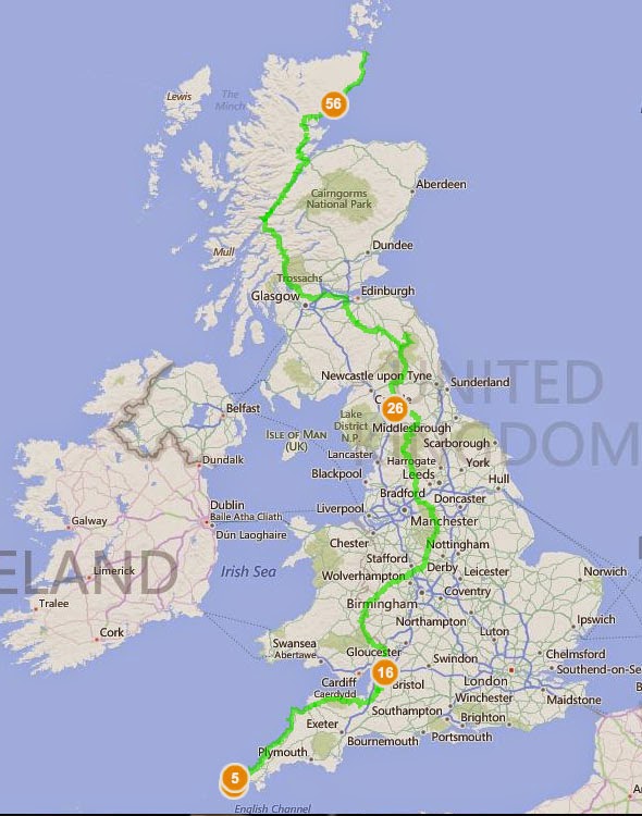
End to End - Lands End to O'Groats on Foot, Route planned on Bing's Free Ordnance Survey Maps

http://www.bing.com/maps/?v=2&cp=52.952792~-3.075215&lvl=7.06&sty=s&cid=EB5023FD3693F27!220&form=LMLTEW
                     CLICK ON THE MAP AND ZOOM TO SEE THE ORDNANCE SURVEY MAPS

View Larger Map  |  Get Directions  |  View Bird's Eye

Possible route from Lands End to O'Groats on Foot. Just spent the last three days plotting it across Bings Ordnance Survey Maps- did you know they had them free across the whole of England!!!! This has definitely earned them my love.
Does anyone know an easy way to avoid trudging up the A roads at the end? I'm trying to navigate a different route but I suspect it'll be me lost in moor land swearing and daydreaming about passing cars and tarmac. 
  Over the next few weeks I'll be breaking down the walk into smaller sections and playing around with possible alternatives but I wanted to get a better idea of the distances and terrain first. Boy is it daunting. Any advice PLEASE email.

  Route tracked a mixture of Andy Robinson's route in 'The End to End Trail' (books bloody heavy, no way I'd carry that with me and the maps are a little confusing but it is helpful) and  'When I Walk, I Bounce: Walking from Land's End to John o'Groats ' by Mark Maxon (personal account of the walk, not guide, but funny and engaging)

This route partly goes along the following National Trails:

South West Coastal Path
Offa's Dyke Path
Pennine Way
West Highland Way
Great Glenn Trail 

I've partly chosen it because it covers half of Offa's Dyke instead of remaining more central and walking up the Cotswold Way. I've done the majority of the Cotswold Way already and find open moors more more appealing than a long stream of golf courses.

DISCLAIMER - other peoples routes and I've yet to walk them. All this is is a very carefully plotted trail based on their instructions.