Showing posts with label England Landscape. Show all posts

Sunday, 28 June 2015

Day 55 - Queenzieburn to Drymen 22 Miles

    It rained all night, and by the time I woke up there were nearly twenty slugs on my tent. Removing them was not the funnest task I've ever I've had in the morning. All night I'd been sliding down the tent and my legs had stiffened horribly.
  I trotted down the slope to the gate I'd past yesterday, the ground before it became very boggy. Peering out I climbed over and felt the sudden relief of having done something naughty and gotten away with it. The path back down was as steep as I remember it. Once back on Queenzieburn I carried straight on towards the next section of Forth and Clyde Canal, the rain also continued and my rain pants were no not merely split as gaping. There must look ridiculous.
Bike track along Glazert Water
  3 miles more of canal and then I was off into Barleybank and a quick break in a McDonalds, breakfast and internet. I also enjoyed their toilet facilities after my camp in the wilderness. From there I switched between the canal path to a bike track along Glazert Water. I barely noticed Lennoxtown as I skirted it and then along the fields near to the rather impressive Dunglass mound into Strathblane. A hotel here provided me with tea and yet more internet. Gladiator soundtrack, which I'd downloaded at McDonald, had bawled me over and I was listening to it a third time. I took this break as a chance to get a few more of Hans Zimmer's work, grinning when I got confirmation that he had in fact
written Pirates of the Caribbean.
Dunglass Mound


On reaching the WHW
  Finally the West Highland Way!!! There was a struggle between Strathblane and joining the trail, the path going through overgrown fields where the route is too indistinct to work out where the hell I'm meant to go. Without View Ranger GPS there is no way I'd not have gotten very lost here. In the end I ran across a field full of horses and joined the road, putting up with traffic for a clear path.

 West Highland Way began with a nice easy track, flat and wonderfully clear of brambles and nettles. I'd already walked nearly 20 miles my this point and boredom was not only welcomed but cherished. I played the Gladiator soundtrack again and grinned my head off having completed a section of the walk I was dreading. There would be campsites galore from now on. More than than Wimbledon was about to start! Life was good.   I reached camp and was shocked at the amount of other small portable tents tottered around the campsite. In the past weeks I'd seen maybe half a dozen other hikers traveling with a pack, and there was that number here in one night. East Drumqyhassle Farm is a lovely camp, the grass was a little long but there was a shelter for the kitchen, showers were included and it ran on a honesty box where you paid the mere £5 fee. I love these rough and tumble campsites and they offer just as much as the larger corporate  ones. They feel more homely and safe, moreover no fire code prevents them from offering up pluck sockets. something I cherish above all things after a nights wild camping.  

East Drumqyhassle Farm campsite

https://www.givey.com/c/girlgoeshiking


Saturday, 27 June 2015

Day 54 - Linlithgow to Queenzieburn 25.5 miles

 Last night I debated leaving my tent in camp and catching a train back at the end of the day. There is no campsite between here and the West Highland Way, I have also been told that I would be passing through some of the poorer and rougher parts of Scotland. Yet the train would in total equal £14, plus the cost of another night at the campsite (£8) would be too much and I found myself packing up in the morning. I'm also dependent on the freedom my pack gives me to carry on as long as I want without been worried about not reaching the target.
Union Canal
Falkirk Tunnel
  The Union Canal was on top of a raise in the ground but once I'd reached it the entire day would be completely flat. Knowing this I set a quicker pace than normal eager to get some distance covered. From here there is very little to describe, the canal is pretty but for the first 10 miles the path consists of just that: a river style canal, sun, and either fences of crops of wood land on either side. At one point there is a 800 meter tunnel which was a little disconcerting, I used to ride through one of similar lengths in Bristol, but its very different walking though it at 2.5 miles an hour.
   The Falkirk Wheel is an impressive sight, grand in scale and full off sightseers. I stopped to look around a little, bought a bottle of ice tea and at some rubbish from my bag. From here I switched to the Forth & Clyde Canal and began to trudge onwards. My feet had already began to ache so I switched to my sandals.
Falkirk Wheel
  At Kilsyth I headed into town in search for some snacks before heading into the hills. 20 miles already complete I was foot sore, though my legs felt find after hardly having to climb a single hill. Liddle provided me with necessary nourishment and I kept an eye out for somewhere to fill up my water. The pub I was aiming for turned out to be burnt to the ground, a common problem it seems in Scotland. A man was using a hose to wash his bike and approaching him asked him to fill my water bladder.
  At Queenzieburn I began to climb towards the Gray Mare hills, up a very windy steep lane. It was actually a relief to be using my leg muscles a little. A man on his way down suggested I try the first farm to my left, drop his name and asked if I could camp on his land. This is something I should have done every time I wild camped. Bracing myself, hoping a woman answered the door I waited. An old man with a half full mouth answered and denied me. I left embarrassed and slightly upset even though he'd answered cordially enough. Seeing empty fields all around I felt rejection. I didn't stop at any other farms and struggled up another mile before starting to seriously look around for a camp.
  Once I reached Corne farm I circled back, climbed over a stone wall and wondered through the woods near Corrie Plantation. The land is steep and a lot of it boggy but I felt sheltered and secure that no one would stumble upon me. I planted my tent and crawled inside without eating much. As I did so rain began to fall and continued all night which is exactly what you most want when wild camping and are uncertain of the neighborhood. No one goes wondering around the hills in heavy rain. I knew I'd spend a lot of the night slipping down to the end of my tent, the patch I'd chosen was hidden and dry which I figured was adequate compensation against the gradient. I do miss my inflatable mattress though, this foam one is rubbish. I felt its inadequacy even more so since that my entire body was stiff from 26 miles walking with only a half hour break. 
Camp

Tent further away in the woods so that you can see just how hard it would be to spot me

From ten meter away its hard to see, from the path I wouldn't be able to see it
  
https://www.givey.com/c/girlgoeshiking

Saturday, 20 June 2015

Day 47- Bellingham to Byrness 14 Miles


  This is my second time on the Pennine Way I find myself comparing the experiences closely. Today, two years ago, I only got through today by finding a really exciting Dick Francis. The guide suggests this stretch as a doddle but there are a few steep steep areas and areas of boggy ground. Moreover a lot of today is through logging areas and extremely dull.
  I was set to go by eight and began by heading north out of town. The lane up White Hill was heralded by a dog's bark but as the wall rose and I fell out of view the dog lost interest. From the farm I crossed a series of fields, passed bunches of trees and onto open moor land and School Crag. GPS led me astray again, and instead of trusting the well trodden path I headed across land. Even when I was directly on top of the green digital line the more I was actually stood on lay untouched by boots of any kind. I ate a lot of Pringles in this field.
Padon Hill
  Once I was passed Hareshaw House things got simpler, and although I was nervous of the cows I reached the B6320 untrampled. A long procession of bicycles whizzed path, as well as support cars. I ducked through a gap and wondered up to Grouse Butts. I've no idea how I worked this route out on paper maps, having relied solely on my phone I felt blind without its help. Whitley Pike is somewhat unremarklable and another concern was pressing me forward. I really needed the loo.
Whitley Pike
  On the way up Brownrigg Head I met another Pennine Way hiker, a girl walking alone. and just at the top of the hill I met yet another sole female hiker. I love talking to them, the conversation is so different to when I talk to male actors. There is no comparison of mileage, or competitiveness, just compliments and commiserations. I warned them about the slabs before Hadrian's Wall and we parted ways.
  I reached Byrness Border Campsite at half three. The lady couldn't find a reference to my walk in her booking sheet but trusted me and allowed me to keep my free pitch. She was lovely and introduced me to their pet donkeys. Since the sun was still up and bright I hand washed an outfit, underwear and a few socks before hanging them out to dry on the barbed wire behind my tent. On the way to the showers I saw a couple hike in with a dog, both carrying rucksacks. Finally some End to End hikers!! I spent a very enjoyable evening talking to them. Both retired and experienced hikers, walking it to raise funds for guide dog training.

https://www.givey.com/c/girlgoeshiking


Friday, 19 June 2015

Day 46- Haltwhistle to Belligham 23 Miles

 My fears over waking those near me proved unfounded as the couple beside me woke beforehand and were also packing up. By eight I was set to go and made the brief climb back up to the lane heading into Haltwhistle. A farmer was herding the sheep in the nearby field as I passed, one dog running alongside while the other stood balanced on the boot of the quad.
Bellister Castle in Haltwhistle
  Walking along the roads I had my usual healthy breakfast of bourbon biscuits and listened to loud
music in the hope that the sugar and the beat would energize me to tackle what would be a hard days walk. Bellingham is 23 miles from the campsite, mainly through logging forests but also across boggy moors and a few miles along Hadrian's Wall. I remember, last time I walked this stretch I reached camp quite exhausted just after dark around 10pm.
Leaving Haltwhistle behind
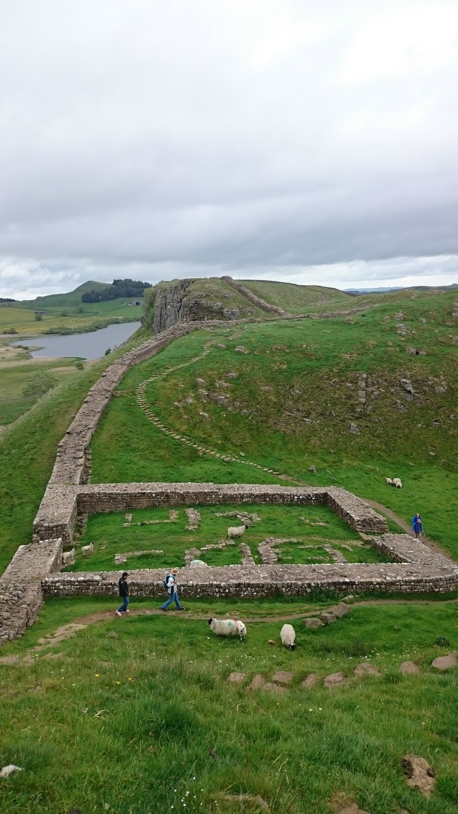
Hadrian's Wall
  Once through Haltwhistle, and passed all the kids heading to school, I made my way into the hills to cover the few miles to Hadrian's wall. The path is a little deceptive and I wondered in zigzags staring at my GPS location. I was listening to a new author called Nevada Barr, first person narrative crime fiction, centered around an outdoor ranger in the American Rockies. Narrative voice far too girly for me, lots of rhetorical questions and thought processes.
  Once I reached Twice Brewed I popped into the tourist information center for a cup of tea and a change to quickly boost my Ipod battery. They were showing a documentary on boat building in the region and I enjoyed a brief break watching it and writing postcards.
  I forgot just how pretty Hadrian's Wall was, hard work and crowded but really pretty.  Having joined it only at Twice Brewed it was also a very short visit and within an hour I was already descending down to Ridley Common, past Broomless Lough and into the woods. Since the rain had been falling over the last week the path slabs were under a few inches of water. I accidentally stepped off one and found my food sinking to the thy into water bog. The foot didn't even hit the bottom. With my balance already committed I fell fully on my left knee and the backpack did the rest of the work landing me straight on my face.

  I lay face down for a few seconds in several inches of water as my body checked itself over. Once my inventory was completed I found the rucksack weighed considerably more now that it was mostly
against my neck, and as my foot had been underwater for several seconds I could feel water entering my boot. A lovely situation. I prioritized getting my foot out the water and crawling to my feet shrugged the rucksack back into place and glanced behind me towards Hadrian's Wall to see if anyone witnessed my performance.
  Using my poles as guides I made painfully slow progress across the path, constantly checking to see the exact position of the slabs and avoid another fall. My trusty Keen boots seemed to have kept the majority of the water out and while my trousers were muddy all the way to the upper thy nothing was hurt. For a second, when I fell, I saw images of smashed knees so I considered myself lucky.
  The rest of the day was uneventful and a little dull. I diverted from the Pennine Way a little and instead of struggling across Haughton Common I stuck to the logging paths. I was still left with a rather deep and long puddle to cross before Shepherdshield but on the whole the track was dry and clear. Once I left the shades of the forest I took the shortest and easiest route over the farm land into Bellingham.
Last stretch towards Bellingham
  Nearer the town I talked to a gentleman for a while, 50 year old cyclist here for a weekend race. I felt a little uneasy about him but we parted ways soon enough and I made my way to the Co-Op and then camp. A noticed another hikers tent but saw no sign of the occupants. Made myself a rather good chorizo noodle soup thing and read a little of the book, although it I were being honest this was mainly to impress the very attractive camper who past me. He also sat outside him tent and read, not that I watching. No car but the chair suggested he'd not be walking along with me tomorrow. Quite a pity.

https://www.givey.com/c/girlgoeshiking


Wednesday, 17 June 2015

Day 44- Dufton to Garrigill 16 miles


From the very first day of my walking Land's End to John o'Groats I'd dreaded today's challenge. Having had such great weather over the course of the last week my trepidation had lifted. In good weather you're meant to see a long way from the top of Cross Fell.It is the highest point of both the Pennine Way and the End to End and you'd have earned it having climbed from 160 meters to just under 900 within 9 miles on open moor land.

  I woke to rain and as I climbed out of Dufton along Hurning Lane was forced to concede that the weather forecast was correct and I'd be forced to tackle rain, mist and winds- just like last time. The climb wasn't so bad, I trudged very slowly but with no breaks and was shocked at how much easier I found it. As I began to get higher the wind picked up and visibility dropped to five or so meters. With my boots on my back dry and protected my feet remained exposed in my sandals. For a large part of today my feet were deep in water and bogs and it was inevitable that I slipped and fell flat on my face at least once. When it did happen it was dramatic but quick and relatively painless. My mood was more affected than anything else, and my left half was now covered in mud. At some point the wind had also ripped away my sack rain cover and my once protected boots were steadily been soaked.
   By the time I skidded down Cross Fell I was shacking with cold, soaking wet and desperate to escape the winds. I reached Greg's Hut and struggled to write in the blog book because my hands were too cold. In this shelter I cooked myself some soup and dipped my last two wraps into it. Food helped a lot and I left feeling considerably warmed. I can imaging Greg's Hut having saved a few lives, it's still high at 700 meters but sheltered from the wind has a wonderfully welcoming feel. Other hikers have left a mountain of things, soups, lighters and snacks. The path down is easy enough. The first time I did it, two years ago, it shredded what was left of my feet but they've toughened over the last few weeks. In the Hut I changed into my boots.
  At reaching Garrigill my earlier weariness had lifted and I was tempted to walk on but with no certain destination and a free camp behind the hall I dropped my stuff and pitched my tent. By this point I was out of food except for a packet of instant mash, the pub wasn't open and the post office was also shut when I reached town at 4:30. The only upside to a far too Spartan night was a basket of moisturizers in the ladies toilets- although I'm unsure if they had any affect when layered over several millimeters of grime.

https://www.givey.com/c/girlgoeshiking

Sunday, 14 June 2015

Day 41 -Hawes to Tan Hill 18.5 miles

Climbing upto Grand Shunner Fell
Looking back at Hardraw
 The climb up to Grand Shunner Fell is the largest challenge today and, since it's stretched over 5 miles, isn't too bad. The weather however made up for this blowing wind and rain through out. I passed the usual gaggle of Duke of Edinburgh students and one was kind enough to pull by backpack  cover back in position for me.
River Swale just after Thwaits

  At Thwaits they passed me as I ate a bacon bab at the B&B cafe. It worries me that I seem to be going to exactly the same places I visited last time and having exactly the same meals. Says bad things about my adventuring spirit.
Keld Falls
  A lovely clamber onto Keld before the climb up to Tan Hill, the highest pub in the country. They were showing the football so hparking my bum I failed to write any of my blog but spent my time instead defending Rooney against the petty judgements of the group of men on the table beside me.
Tan Hill
  The pub was having an off night, the bar tender rather rubbish forgetting three times things I'd asked for and drinking behind the bar between cigarette breaks. Not the place I'd loved on the last visit. It was however brimming with walkers to talk to and I met a load of interesting people.

https://www.givey.com/c/girlgoeshiking

Tuesday, 9 June 2015

Day 36- Colden to Cowling 14 miles

   Struggled today, got lost in the moors leading to Clough Head hill and was forced to trudge through open moors to get back to the path- thank God for G.P.S. and View
Hunting hut? Along the path towards Lower Withens
Ranger. Trudging around Gorple Lower Reservoir you climb back up the steep banks to Withering Heights End at 448 metres before reaching Ponden Reservoir. Waking towards me was another End to Ender walker doing it north to south. He's the second hiker I've seen with pouches on his front half as well as his back, its meant to stop you leaning back but I think I'd end up stooped by the end of the day.
Winter House Barn Camping Field

  The climb to Great Wolf Stones quite did me in and reaching Cowling I gave up the ghost that I could walk all the way to Gargrave. I stumbled into Winter House Barn Campsite and pitching my tent wondered into town to find some Wifi. The campsites was a basic affair behind a B&B full of friendly chickens. Set just far enough away from the road and quiet it was exactly my cup of tea. The only annoyance was the clock tower whose electronic chimes marked every quarter of the hour.


https://www.givey.com/c/girlgoeshiking

Monday, 8 June 2015

Day 35- Standedge to Colden 18.5 miles

    Today's walk was easy enough. The Pennine Way joins Oldham Way over the moors and towards the M62. The path is well trodden and, today, dry. I found myself at the same burger van as on my last Pennine Way walk and ordered myself a fried egg sandwich. The road before it was packed and asking why I found that the
Shut M62
M62 had been shut after a terrible crash. The cars were practically standing still going into
Manchester which made crossing easy. It was strange, a little while later, crossing over the deserted M62.
  Stopping briefly at the White House Inn I ordered a coke and tried to update my blog using their Wi-Fi. The White House Inn was busy, like the last time I'd come, and felt welcoming and warm. I stayed an hour or so before moving on. I was far too aware that it was only twelve and if I was planning to wild camp I'd be reaching my goal far too early.
Blackstone Edge Reservoir
  Whenever you take a break above five minutes your muscles stiffen and you forget how to walk, or at least my legs do, and it takes a few minutes for me not look ridiculous. As I passed the rather impressive monument Stoodely Pike I had a rather impressive noise bleed. I've had two so far after the walk from Edale, not brilliant things to have when without tissues. I think it's due to high winds and rough noise blowing.
Stoodley Pike

Stoodley Pike fading in the distance
 The path down to Charleston Valley (around the corner from Hepden Bridge) was simple enough and the climb up Dry
Lower Pilling
Hill just as steep and draining. More so since the moment you're up you're going back down to Lower Pilling. I remembered that around here the was a shop called Aladdin's Cave and kept my eyes peeled hoping that they would still be open.
View from May's Aladdin's Cave back towards Stoodley Pike
 They were. May's Aladdin's Cave Shop is a small building at the entrance to a farm about 200 yards from the Pennine Way path, and is packed to the ceiling with everything you might wish for. The owner is also a very special women, friendly, interested and happy. While talking she told me of some campers they'd had yesterday, I asked in surprise if they were also a campsites. Apparently long distance hikers can camp for free and use the outside toilets and fresh water spring in their yard. I eagerly cut my walk short, made camp and are my newly bought treats.
Campsite at May's Aladdin's Cave campsite
https://www.givey.com/c/girlgoeshiking