Showing posts with label Hiking Boots. Show all posts

Sunday, 21 June 2015

Day 48- Byrness to Jedburgh 21.5 Miles


Rain whipping through the Redersdale Forest
  With bad weather on its way I was up earlier than before and set off still not completely sure whether I was walking to Kirk Yetholm or leave the Pennine way for a more direct route. The other End to Enders were awake and packing up as I left. I spent a large portion of the morning waiting for them to catch me up but I never saw them again.
Looking down from Byrness Hill to the Northumberland National Park and the Catcleugh Reservoir
 The path goes straight along the River Rede before crossing into the hamlet, Byrness. A priest waved as I past. The climb up to Byrness Hill is a hard on, windy and steep. The last five meters to the top is quite a scramble, and horribly awkward with the rucksack. I also felt tired and worn out by the last few days, and even on top I seemed to struggle. What didn't help was the weather whipping at me in showery waves as the clouds were blown across my path. One minute I was shielding my face from the weather, the next I was sweating under layers of waterproofing.
Dere Street Roman Road

 When the decision on today's destination came the weather made it and I headed towards Blackhall Hill and the more direct route into Scotland and towards the West Highland Way. The hills down towards Langside Law are lovely rolling meadows, the path easy and wonderfully firm after the boggy moors. I stopped along a lane for breakfast and since I was overheating in earnest now pulled
off my rain trousers and coats. By the time I finished my sandwich it wasn't raining it was hailing painfully. I pulled back on my now damp trouser covers and hurried off. Head low under a hood I can't say I appreciated the landscape around me. I'd reached the Roman Road though and it was straight and puddle free. Along 'Dere Street' Roman Road I was chased my a herd of very excited calfs on the other side of the fence, further on there was another field with the biggest bull I'd ever seen in my life. This beast was nothing like the two year calfs I'd seen with rings in England, he towered over the others in the field, his front chest thrust out and thrown into relief by his small hind. If he was in a field I needed to cross I'd be willing to walk several miles around.
  The Roman Road carries on for the next 8 or so miles and while it is pleasant its also a little dull. Jedburgh, however, slowly came closer and I decided to make the 2km diversion towards the town and the campsite. I'd not checked online and just after I descended through Easter Ulston my heart sank to find an empty field where the campsite should have been. Wild camping no longer seemed at all desirable. I wanted a shower. In a grump I walked the last kilometers or so into town to grab some food. I felt truly drained and a little put out by my obviously outdated maps.
  Leaving my rucksack outside I bought a few overpriced items from the petrol station before wondering back out. As I donned my pack I spotted a sign across the road, the campsite!! There was one all along but the maps icon was simple one field off and to get to the entrance you needed to walk round along the roads. Even better it was a Caravan and Campsite Club which meant it would cost me no more than £6.20. An extra treat was that there was another End to End hiker there, a woman walking North to South full of interesting tips for the next stage of my journey. We talked for close to an hour before she received a phone call from her family and I wondered back to my tent for dinner.
Lane towards Jedburgh

https://www.givey.com/c/girlgoeshiking


Friday, 19 June 2015

Day 46- Haltwhistle to Belligham 23 Miles

 My fears over waking those near me proved unfounded as the couple beside me woke beforehand and were also packing up. By eight I was set to go and made the brief climb back up to the lane heading into Haltwhistle. A farmer was herding the sheep in the nearby field as I passed, one dog running alongside while the other stood balanced on the boot of the quad.
Bellister Castle in Haltwhistle
  Walking along the roads I had my usual healthy breakfast of bourbon biscuits and listened to loud
music in the hope that the sugar and the beat would energize me to tackle what would be a hard days walk. Bellingham is 23 miles from the campsite, mainly through logging forests but also across boggy moors and a few miles along Hadrian's Wall. I remember, last time I walked this stretch I reached camp quite exhausted just after dark around 10pm.
Leaving Haltwhistle behind
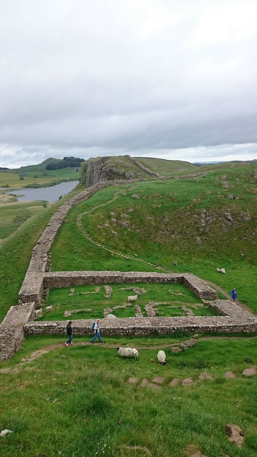
Hadrian's Wall
  Once through Haltwhistle, and passed all the kids heading to school, I made my way into the hills to cover the few miles to Hadrian's wall. The path is a little deceptive and I wondered in zigzags staring at my GPS location. I was listening to a new author called Nevada Barr, first person narrative crime fiction, centered around an outdoor ranger in the American Rockies. Narrative voice far too girly for me, lots of rhetorical questions and thought processes.
  Once I reached Twice Brewed I popped into the tourist information center for a cup of tea and a change to quickly boost my Ipod battery. They were showing a documentary on boat building in the region and I enjoyed a brief break watching it and writing postcards.
  I forgot just how pretty Hadrian's Wall was, hard work and crowded but really pretty.  Having joined it only at Twice Brewed it was also a very short visit and within an hour I was already descending down to Ridley Common, past Broomless Lough and into the woods. Since the rain had been falling over the last week the path slabs were under a few inches of water. I accidentally stepped off one and found my food sinking to the thy into water bog. The foot didn't even hit the bottom. With my balance already committed I fell fully on my left knee and the backpack did the rest of the work landing me straight on my face.

  I lay face down for a few seconds in several inches of water as my body checked itself over. Once my inventory was completed I found the rucksack weighed considerably more now that it was mostly
against my neck, and as my foot had been underwater for several seconds I could feel water entering my boot. A lovely situation. I prioritized getting my foot out the water and crawling to my feet shrugged the rucksack back into place and glanced behind me towards Hadrian's Wall to see if anyone witnessed my performance.
  Using my poles as guides I made painfully slow progress across the path, constantly checking to see the exact position of the slabs and avoid another fall. My trusty Keen boots seemed to have kept the majority of the water out and while my trousers were muddy all the way to the upper thy nothing was hurt. For a second, when I fell, I saw images of smashed knees so I considered myself lucky.
  The rest of the day was uneventful and a little dull. I diverted from the Pennine Way a little and instead of struggling across Haughton Common I stuck to the logging paths. I was still left with a rather deep and long puddle to cross before Shepherdshield but on the whole the track was dry and clear. Once I left the shades of the forest I took the shortest and easiest route over the farm land into Bellingham.
Last stretch towards Bellingham
  Nearer the town I talked to a gentleman for a while, 50 year old cyclist here for a weekend race. I felt a little uneasy about him but we parted ways soon enough and I made my way to the Co-Op and then camp. A noticed another hikers tent but saw no sign of the occupants. Made myself a rather good chorizo noodle soup thing and read a little of the book, although it I were being honest this was mainly to impress the very attractive camper who past me. He also sat outside him tent and read, not that I watching. No car but the chair suggested he'd not be walking along with me tomorrow. Quite a pity.

https://www.givey.com/c/girlgoeshiking


Thursday, 18 June 2015

Day 45- Garrigill to Haltwhistle 16 Miles


   Today's walk was a pleasant change of pace from yesterday's trial. Instead of sticking strictly to the Pennine Way, through Slaggyford and over Hartlayburn Common to Greenhead, I joined the South Tynedale Railway trail at Alston and struck to it for the rest of the day. This meant flat walking and clear tracks, and the lack of navigation would allow me to tune out completely.   
River South Tyne before Alston
  The first stretch of today is along the banks of River South Tyne for five miles although it feels longer. The path switches sides and meanders through farm land and through styles and fences galore. Since I'd had no food for breakfast I reached it hungry and in need of a sugar fix. I ended up in the same cafe I'd gone to on my last Pennine Way jaunt and it didn't impress me any more than it had last time. That said I left with my hunger abated and wondered round town. First stop was to the outdoor shop to procure another backpack cover, I also bought a pair of glove liners to help keep my hands warm on cold nights.
  A few shops later my backpack was heavy again but I had enough food for a couple of days and felt a little less stressed. The beginning of the South Tynedale Railway walk goes along a tourist attraction with working stream engines pulling carriages back and fourth. The path is stoned with the same stones as the tracks and made for uncomfortable walking. I hoped it would change at some point to flat dirt and give my souls a rest. 


  After a couple of miles and a few quaint stations I past a digger and the path dissolved into an overgrown trench whose flatness was the only indication that a train track was ever there. This line was constructed during the C19th to transport lead, coal and limestone from the Alston mine fields to Halwhistle and then east towards Newcastle. It was also vital to the communities isolated in rural parts of England during the winter months. wit the whole line been shut in 1976 the path and the Lambley Viaduct slowly fell to pieces. It was only in 1995 that the Lambley Viaduct was restored and reopened. It's the highlight of the day, tall and elegant it's everything you associate with the romance of the railway and walking over it you're treated with 17 metre high views of the river and land below.  The track continues straight and true, once in a while a crumbling station is visible but mostly it's just a pretty path between small towns.
 

   Although only 16 or so miles I was happy to reach camp and pitch at Haltwhistle Camping and Caravanning Club Site. The campsite was a lovely one and I found Master and Commander in their second hand bookshelf. Buying it, and some rice and chocolate, I settled in. They placed all the tents close together but that was my only complaint and while my neighbors snore was quite impressive my earphones preserved my sleep.

Haltwhistle Camping and Caravanning Club Site

https://www.givey.com/c/girlgoeshiking

Wednesday, 17 June 2015

Day 44- Dufton to Garrigill 16 miles


From the very first day of my walking Land's End to John o'Groats I'd dreaded today's challenge. Having had such great weather over the course of the last week my trepidation had lifted. In good weather you're meant to see a long way from the top of Cross Fell.It is the highest point of both the Pennine Way and the End to End and you'd have earned it having climbed from 160 meters to just under 900 within 9 miles on open moor land.

  I woke to rain and as I climbed out of Dufton along Hurning Lane was forced to concede that the weather forecast was correct and I'd be forced to tackle rain, mist and winds- just like last time. The climb wasn't so bad, I trudged very slowly but with no breaks and was shocked at how much easier I found it. As I began to get higher the wind picked up and visibility dropped to five or so meters. With my boots on my back dry and protected my feet remained exposed in my sandals. For a large part of today my feet were deep in water and bogs and it was inevitable that I slipped and fell flat on my face at least once. When it did happen it was dramatic but quick and relatively painless. My mood was more affected than anything else, and my left half was now covered in mud. At some point the wind had also ripped away my sack rain cover and my once protected boots were steadily been soaked.
   By the time I skidded down Cross Fell I was shacking with cold, soaking wet and desperate to escape the winds. I reached Greg's Hut and struggled to write in the blog book because my hands were too cold. In this shelter I cooked myself some soup and dipped my last two wraps into it. Food helped a lot and I left feeling considerably warmed. I can imaging Greg's Hut having saved a few lives, it's still high at 700 meters but sheltered from the wind has a wonderfully welcoming feel. Other hikers have left a mountain of things, soups, lighters and snacks. The path down is easy enough. The first time I did it, two years ago, it shredded what was left of my feet but they've toughened over the last few weeks. In the Hut I changed into my boots.
  At reaching Garrigill my earlier weariness had lifted and I was tempted to walk on but with no certain destination and a free camp behind the hall I dropped my stuff and pitched my tent. By this point I was out of food except for a packet of instant mash, the pub wasn't open and the post office was also shut when I reached town at 4:30. The only upside to a far too Spartan night was a basket of moisturizers in the ladies toilets- although I'm unsure if they had any affect when layered over several millimeters of grime.

https://www.givey.com/c/girlgoeshiking

Tuesday, 2 June 2015

Day 29- Brocton to Uttoxeter 18.5 miles

Brocton
   I seemed to escape the worst of the weather while packing although as I left camp the drizzle started and didn't stop till I reached Little Haywood. The rest of Brocton was lovely although heavily signed with 'No Camping' signs but since I'd had little choice I couldn't feel too bad about it. From my
patchy foresty area you climb across a car park and onto more open moor land. I then descended gently into Trent Valley, crossing some lovely step stones over Tent River before leaving the park and approaching Little Heywood.

  For some reason my boots were wet again and the side of my left ankle was rubbed raw. I stopped along the River Trent and plastered myself but soon after gave up and changed into my sandals. The path along the river was lovely, longboats passing and waving. Over one section you have the canal on one side and a wider river on the other, the past an island between the two. You carry on West, going over Rugeley and around Blithfield Reservoir.
  I saw some builders near the reservoir who joked at me wearing sandals, shooting something back I continued down. The path crosses a series of fields, nettles causing havoc to my legs. Already I'd been forced to climb fences in order to avoid cows, here though I had no choice. There were calfs in the field so I made a real effort to keep my
distance, paddling across the river instead of using the bridge and staying on the edge of the field. A calf lay nearish and, presumably, his mother walked over to guard it. I figured I was in the clear when I got a hundred or so metres away but it suddenly charged. Didn't realise how fast the buggers could move. I ran and in order to climb over the fence threw down my hiking poles. By this point the herd had become interested, as had a bull who'd been wondering round. Dumping my bag I jumped back over the fence before they could all arrived and retrieved my poles. The charging cow backed off with a good shouting at although her sprint seemed to have impressed the bull and she was also soon distracted.
  Once I reached Abbots Bromely I stopped in a pub for some lunch, and to recharge my low batteries. Two nights wild camping meant I would soon have no phone and therefore no maps. With this in mind I took my time eating, leaving the office plugged in as long as I could.
Uttoxeter Racecourse Campsite

  By the time I reached Uttoxeter I was tired and a little fed up as my shopping bag burst and I was left cradling my groceries. I also totally missed the campsite and walked twenty minutes the wrong way. This was because if wrongly assumed the campsite and racecourse were two different places. Still, once pitched I enjoyed the novelty and felt an urge to listen to more of my Dick Francis collection. I spent most of the evening doing my laundry, by hand, and then waiting for the tumble drier to finish. A long shower followed as I worried over the ache in my back. I wondered if I'd pulled something running from the cows and jumping over the fence. It wasn't till a little later that I realised what had caused it, not the hiking or anything adventurous but the laundry. By morning it was gone.

Thursday, 22 January 2015

Gear Review - Scarpa Ranger II ActTX Womens Walking Boots


 Bought - May 2013 
Distance - 300 Miles
 Price - 160.00
  Shoe Size - 7 

PROS

  As advertised they are waterproof and insulating, protecting you from the path with impressively thick and hard soles. These boots are hard and built to last. They look like they've been taken a strolls over the fields not 300 miles over moor land, through marshlands and gravel lanes and roads. Scarpa boots are designed to survive pretty much everything. The only problem is my feet might not survive them over the course of another walk.


 CONS

    I bought these in preparation for the Pennine Way. They are heavy boots, the ankles cushioned and very well padded fixing your foot in place. They advertise that "Auto-fit foam inserts in heel area provide perfect foot hold and increased comfort" and for the first twenty miles this is fine, and while they aren't as cushy as they appear in the shop they seem fit for the job. By the fortieth mile however things go down hill. First its important to note that I have wide feet and not dainty skinny ankles. I suspect shoes are like a kiss and its not about how skilled one person is but how they fit together. These boots and I were never meant to be. For the entire Pennine Way, 250 Miles, they game me hell blistered my left heel and compressed it so that it could hardly carry any weight. I only carried on my heavily plastering it and wearing a supportive bandage. I assumed I'd just not broken them in enough, that my feet had just not hardened to the trail, but since then I've come to realize that it wasn't me it what the boots. On the Cotswold Way, a 100 mile walk, they'd given me five blisters on one foot and three on the other by the second day, and soon after my heel began to hurt for the first time since the Pennines. I've concluded that the constraints around the heel compressed my ankle too much, as my feet were simply too wide. Even if they did fit well its also worth noting just how heavy these boots are, and once they're wet they drag.

Upper Material: Leather
Waterproof: Yes
Waterproof Technology: GORE-TEX®
Height: Boot Cut
Insole: Viscoflex Activ fit insole with memory foam
Midsole: Hi-Flex
Sole Type: Vibram®
Stiffness: Soft, for low level walks on defined trials
Lacing Type: Standard Lace Up
Boot Grade: B0 - not suitable for crampons
Ideal Crampon Rating: Not Crampon Compatible

 
CONCLUSION

   I wouldn't buy another Scarpa boot. In fact I took quite a lot of pleasure in selling them on ebay and using the money to buy myself a forty pound pair of Trespass walking boots. These Trespass boots are light, waterproof and an instant match. I took them on a thirty mile hike and didn't get a single blister. I hated how heavy Scarpa boots were, hated putting them on in the morning and there are simply not enough plasters in the world to make them comfortable.