Monday, 22 June 2015

Day 49 - Jedburgh to Galashiels 21.5 Miles


  Once again I've pushed my body long enough that it is now desperate for a day off. I woke up to the rain and wondered whether I should simply drift back to sleep and hang out here for the day. Ten minutes later I still found myself packing up. Melrose was a simple 14 or so miles away, there would be a long line of shops and museums for my day off.
Suspension Bridge over The Hutches
  Rain lessened slightly allowing my to roll up my tent and wrap my rain cover over the pack. As I left I was joined by Janet, the other End to Ender, and we walked the first ten on so minutes together. I wished a little that she was heading my way as I believed she was the type of companion I would enjoy. I took the lane going past New Mill Farm to rejoin the Roman Road and after a short bit of twisting along and across the river Hutches by means of a very handsome wire bridge it straightened out again
Historical sites along the St Cuthberr's Way
into a six foot wide track enclosed by stone walls. Most of today's walk would be along the St Cuthberr's Way and because of this I met a few B&B hikers walking it.
  About this time I heard an interview on BBC4 with the author of the Sharp series, and finding him rather slimy but charming decided to buy and download the first book in his series the next time I found some free WiFi.
  A large part of today is paved roads between small towns. Boswell was the first. I looked for a cafe but finding none ate too many sugary things and made myself feel a little sick. Just before Newton St Boswell two kilometers later I popped into a garden center and bought some soup. A few miles along a disused road called Bolgleburn Strip and I was entering Melrose. There is something very strange about a shut off road, and I confess I had a few flashes to Walking Dead which I enjoyed.
  Before Melrose you have to cross under an A road and twist along several others before you reach the center. Small towers marked the entrance to the town and the high street seemed charming. I figured I'd set up camp and come back after, this was until I found the campsite cost £12. If I took my day off here it would cost me £24 which was too much and, less than graciously, I retreated. Picking up some groceries from the Co-Op I headed out. I'd stop and have a drink of some sort at Galashiels before wild camping above the town. The path to Galashiels is yet another two or so miles of dull pavements and a cycle path around a hospital and along a newly laid railway track.
Looking back down towards Galashiels
  At Galashiels I stumbled over a trading park with giant Tescos and Asda. I popped into both searching for earphones. For the last three weeks I'd been walking with only one earphone working, and that in the last day or so that too had also started to play up. I also restocked my supplies and bought some chicken for dinner. Last task before leaving to attempts to refill my water bladder. Tesco's water was off so I sheepishly crossed the road and approached a shopping clerk in New Look who kindly obliged.
View from my Wild Camp

  The roads up out of the Old Town are of Galashiels is steep and I found myself lost and trapped in the Academy grounds. I walked around towards the tennis courts where two girls helped me out, teenagers playing with roller blades. They also confirmed something that Janet said, another hiker had passed them today and since this was far from a national trail it was probably another End to Ender. I kept my eyes open but saw no sign of him.
  Exhausted I took the first chance to stop and change into my sandals in the hope it would refresh my feet. People seemed to be gathering in the field bellow, cars were parking and there were even parking attendants. I worried that they'd guess I was camping nearby as it was already nearly 8. That said the first hiding place I found I stopped. I reached a clump of trees a kilometer of so after the field called 'Earthwork (course of)' encircled by a broken stone wall. I scrambled over and climbed higher up away from the path until the view of the town opened up below me. Apart from the rather nasty task of clearing the grass of sheep excrement it was a lovely scenic spot with great views and my camp hidden on all sides. Settling down I hate a late dinner before tucking myself into my sleeping back and attempting to go to sleep. Sheep spent a great deal of the night calling to each other which was part of the reason I remained awake till late into the night, but also I kept hearing a voice on a loud speaker down below. It must have been from the field I'd passed but unable to make out what was been said I still didn't have a clue what they were up to. It was nearly midnight when I finally dropped off.


https://www.givey.com/c/girlgoeshiking


Sunday, 21 June 2015

Day 48- Byrness to Jedburgh 21.5 Miles


Rain whipping through the Redersdale Forest
  With bad weather on its way I was up earlier than before and set off still not completely sure whether I was walking to Kirk Yetholm or leave the Pennine way for a more direct route. The other End to Enders were awake and packing up as I left. I spent a large portion of the morning waiting for them to catch me up but I never saw them again.
Looking down from Byrness Hill to the Northumberland National Park and the Catcleugh Reservoir
 The path goes straight along the River Rede before crossing into the hamlet, Byrness. A priest waved as I past. The climb up to Byrness Hill is a hard on, windy and steep. The last five meters to the top is quite a scramble, and horribly awkward with the rucksack. I also felt tired and worn out by the last few days, and even on top I seemed to struggle. What didn't help was the weather whipping at me in showery waves as the clouds were blown across my path. One minute I was shielding my face from the weather, the next I was sweating under layers of waterproofing.
Dere Street Roman Road

 When the decision on today's destination came the weather made it and I headed towards Blackhall Hill and the more direct route into Scotland and towards the West Highland Way. The hills down towards Langside Law are lovely rolling meadows, the path easy and wonderfully firm after the boggy moors. I stopped along a lane for breakfast and since I was overheating in earnest now pulled
off my rain trousers and coats. By the time I finished my sandwich it wasn't raining it was hailing painfully. I pulled back on my now damp trouser covers and hurried off. Head low under a hood I can't say I appreciated the landscape around me. I'd reached the Roman Road though and it was straight and puddle free. Along 'Dere Street' Roman Road I was chased my a herd of very excited calfs on the other side of the fence, further on there was another field with the biggest bull I'd ever seen in my life. This beast was nothing like the two year calfs I'd seen with rings in England, he towered over the others in the field, his front chest thrust out and thrown into relief by his small hind. If he was in a field I needed to cross I'd be willing to walk several miles around.
  The Roman Road carries on for the next 8 or so miles and while it is pleasant its also a little dull. Jedburgh, however, slowly came closer and I decided to make the 2km diversion towards the town and the campsite. I'd not checked online and just after I descended through Easter Ulston my heart sank to find an empty field where the campsite should have been. Wild camping no longer seemed at all desirable. I wanted a shower. In a grump I walked the last kilometers or so into town to grab some food. I felt truly drained and a little put out by my obviously outdated maps.
  Leaving my rucksack outside I bought a few overpriced items from the petrol station before wondering back out. As I donned my pack I spotted a sign across the road, the campsite!! There was one all along but the maps icon was simple one field off and to get to the entrance you needed to walk round along the roads. Even better it was a Caravan and Campsite Club which meant it would cost me no more than £6.20. An extra treat was that there was another End to End hiker there, a woman walking North to South full of interesting tips for the next stage of my journey. We talked for close to an hour before she received a phone call from her family and I wondered back to my tent for dinner.
Lane towards Jedburgh

https://www.givey.com/c/girlgoeshiking


Saturday, 20 June 2015

Day 47- Bellingham to Byrness 14 Miles


  This is my second time on the Pennine Way I find myself comparing the experiences closely. Today, two years ago, I only got through today by finding a really exciting Dick Francis. The guide suggests this stretch as a doddle but there are a few steep steep areas and areas of boggy ground. Moreover a lot of today is through logging areas and extremely dull.
  I was set to go by eight and began by heading north out of town. The lane up White Hill was heralded by a dog's bark but as the wall rose and I fell out of view the dog lost interest. From the farm I crossed a series of fields, passed bunches of trees and onto open moor land and School Crag. GPS led me astray again, and instead of trusting the well trodden path I headed across land. Even when I was directly on top of the green digital line the more I was actually stood on lay untouched by boots of any kind. I ate a lot of Pringles in this field.
Padon Hill
  Once I was passed Hareshaw House things got simpler, and although I was nervous of the cows I reached the B6320 untrampled. A long procession of bicycles whizzed path, as well as support cars. I ducked through a gap and wondered up to Grouse Butts. I've no idea how I worked this route out on paper maps, having relied solely on my phone I felt blind without its help. Whitley Pike is somewhat unremarklable and another concern was pressing me forward. I really needed the loo.
Whitley Pike
  On the way up Brownrigg Head I met another Pennine Way hiker, a girl walking alone. and just at the top of the hill I met yet another sole female hiker. I love talking to them, the conversation is so different to when I talk to male actors. There is no comparison of mileage, or competitiveness, just compliments and commiserations. I warned them about the slabs before Hadrian's Wall and we parted ways.
  I reached Byrness Border Campsite at half three. The lady couldn't find a reference to my walk in her booking sheet but trusted me and allowed me to keep my free pitch. She was lovely and introduced me to their pet donkeys. Since the sun was still up and bright I hand washed an outfit, underwear and a few socks before hanging them out to dry on the barbed wire behind my tent. On the way to the showers I saw a couple hike in with a dog, both carrying rucksacks. Finally some End to End hikers!! I spent a very enjoyable evening talking to them. Both retired and experienced hikers, walking it to raise funds for guide dog training.

https://www.givey.com/c/girlgoeshiking


Friday, 19 June 2015

Day 46- Haltwhistle to Belligham 23 Miles

 My fears over waking those near me proved unfounded as the couple beside me woke beforehand and were also packing up. By eight I was set to go and made the brief climb back up to the lane heading into Haltwhistle. A farmer was herding the sheep in the nearby field as I passed, one dog running alongside while the other stood balanced on the boot of the quad.
Bellister Castle in Haltwhistle
  Walking along the roads I had my usual healthy breakfast of bourbon biscuits and listened to loud
music in the hope that the sugar and the beat would energize me to tackle what would be a hard days walk. Bellingham is 23 miles from the campsite, mainly through logging forests but also across boggy moors and a few miles along Hadrian's Wall. I remember, last time I walked this stretch I reached camp quite exhausted just after dark around 10pm.
Leaving Haltwhistle behind
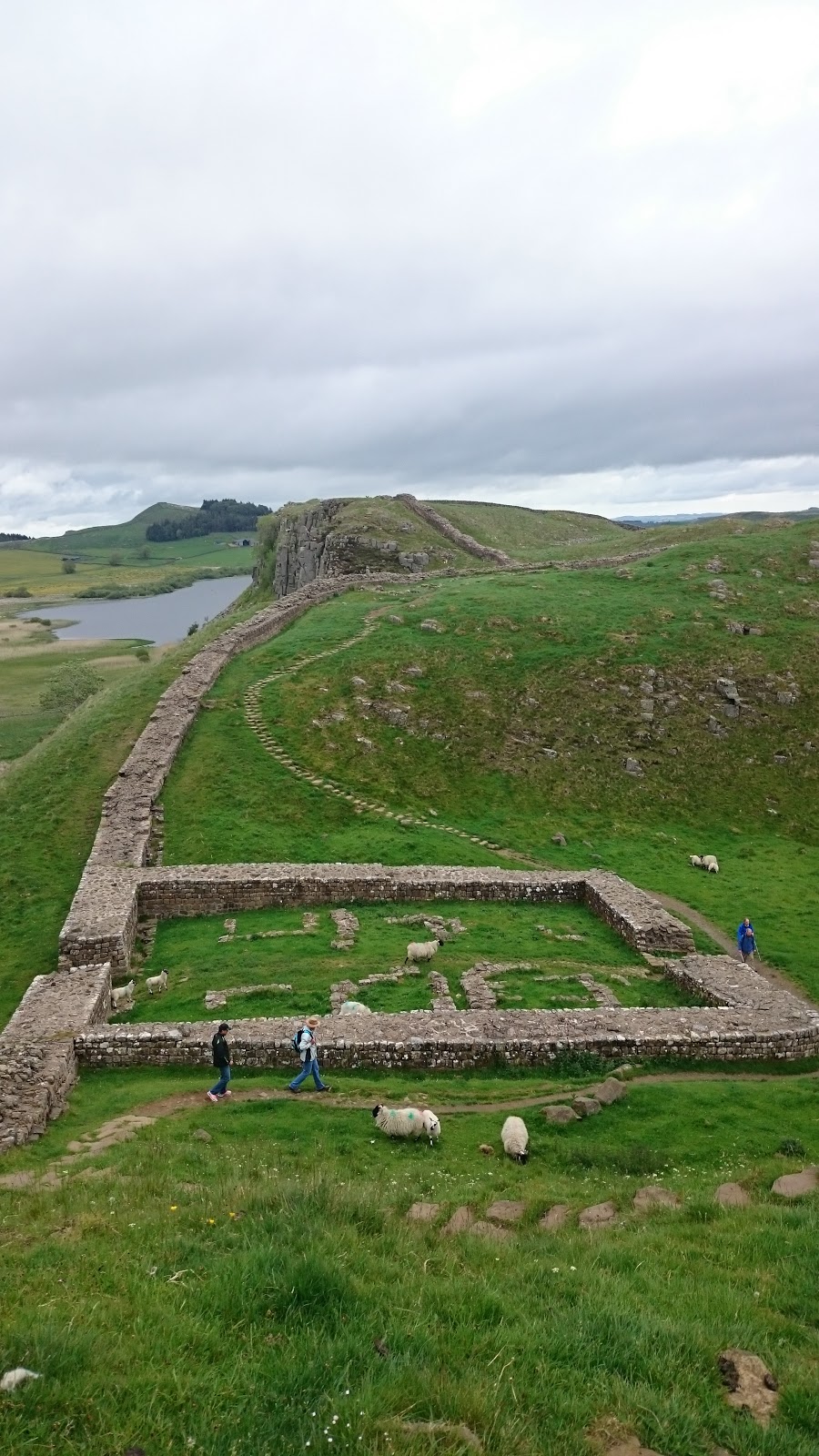
Hadrian's Wall
  Once through Haltwhistle, and passed all the kids heading to school, I made my way into the hills to cover the few miles to Hadrian's wall. The path is a little deceptive and I wondered in zigzags staring at my GPS location. I was listening to a new author called Nevada Barr, first person narrative crime fiction, centered around an outdoor ranger in the American Rockies. Narrative voice far too girly for me, lots of rhetorical questions and thought processes.
  Once I reached Twice Brewed I popped into the tourist information center for a cup of tea and a change to quickly boost my Ipod battery. They were showing a documentary on boat building in the region and I enjoyed a brief break watching it and writing postcards.
  I forgot just how pretty Hadrian's Wall was, hard work and crowded but really pretty.  Having joined it only at Twice Brewed it was also a very short visit and within an hour I was already descending down to Ridley Common, past Broomless Lough and into the woods. Since the rain had been falling over the last week the path slabs were under a few inches of water. I accidentally stepped off one and found my food sinking to the thy into water bog. The foot didn't even hit the bottom. With my balance already committed I fell fully on my left knee and the backpack did the rest of the work landing me straight on my face.

  I lay face down for a few seconds in several inches of water as my body checked itself over. Once my inventory was completed I found the rucksack weighed considerably more now that it was mostly
against my neck, and as my foot had been underwater for several seconds I could feel water entering my boot. A lovely situation. I prioritized getting my foot out the water and crawling to my feet shrugged the rucksack back into place and glanced behind me towards Hadrian's Wall to see if anyone witnessed my performance.
  Using my poles as guides I made painfully slow progress across the path, constantly checking to see the exact position of the slabs and avoid another fall. My trusty Keen boots seemed to have kept the majority of the water out and while my trousers were muddy all the way to the upper thy nothing was hurt. For a second, when I fell, I saw images of smashed knees so I considered myself lucky.
  The rest of the day was uneventful and a little dull. I diverted from the Pennine Way a little and instead of struggling across Haughton Common I stuck to the logging paths. I was still left with a rather deep and long puddle to cross before Shepherdshield but on the whole the track was dry and clear. Once I left the shades of the forest I took the shortest and easiest route over the farm land into Bellingham.
Last stretch towards Bellingham
  Nearer the town I talked to a gentleman for a while, 50 year old cyclist here for a weekend race. I felt a little uneasy about him but we parted ways soon enough and I made my way to the Co-Op and then camp. A noticed another hikers tent but saw no sign of the occupants. Made myself a rather good chorizo noodle soup thing and read a little of the book, although it I were being honest this was mainly to impress the very attractive camper who past me. He also sat outside him tent and read, not that I watching. No car but the chair suggested he'd not be walking along with me tomorrow. Quite a pity.

https://www.givey.com/c/girlgoeshiking


Thursday, 18 June 2015

Day 45- Garrigill to Haltwhistle 16 Miles


   Today's walk was a pleasant change of pace from yesterday's trial. Instead of sticking strictly to the Pennine Way, through Slaggyford and over Hartlayburn Common to Greenhead, I joined the South Tynedale Railway trail at Alston and struck to it for the rest of the day. This meant flat walking and clear tracks, and the lack of navigation would allow me to tune out completely.   
River South Tyne before Alston
  The first stretch of today is along the banks of River South Tyne for five miles although it feels longer. The path switches sides and meanders through farm land and through styles and fences galore. Since I'd had no food for breakfast I reached it hungry and in need of a sugar fix. I ended up in the same cafe I'd gone to on my last Pennine Way jaunt and it didn't impress me any more than it had last time. That said I left with my hunger abated and wondered round town. First stop was to the outdoor shop to procure another backpack cover, I also bought a pair of glove liners to help keep my hands warm on cold nights.
  A few shops later my backpack was heavy again but I had enough food for a couple of days and felt a little less stressed. The beginning of the South Tynedale Railway walk goes along a tourist attraction with working stream engines pulling carriages back and fourth. The path is stoned with the same stones as the tracks and made for uncomfortable walking. I hoped it would change at some point to flat dirt and give my souls a rest. 


  After a couple of miles and a few quaint stations I past a digger and the path dissolved into an overgrown trench whose flatness was the only indication that a train track was ever there. This line was constructed during the C19th to transport lead, coal and limestone from the Alston mine fields to Halwhistle and then east towards Newcastle. It was also vital to the communities isolated in rural parts of England during the winter months. wit the whole line been shut in 1976 the path and the Lambley Viaduct slowly fell to pieces. It was only in 1995 that the Lambley Viaduct was restored and reopened. It's the highlight of the day, tall and elegant it's everything you associate with the romance of the railway and walking over it you're treated with 17 metre high views of the river and land below.  The track continues straight and true, once in a while a crumbling station is visible but mostly it's just a pretty path between small towns.
 

   Although only 16 or so miles I was happy to reach camp and pitch at Haltwhistle Camping and Caravanning Club Site. The campsite was a lovely one and I found Master and Commander in their second hand bookshelf. Buying it, and some rice and chocolate, I settled in. They placed all the tents close together but that was my only complaint and while my neighbors snore was quite impressive my earphones preserved my sleep.

Haltwhistle Camping and Caravanning Club Site

https://www.givey.com/c/girlgoeshiking

Wednesday, 17 June 2015

Day 44- Dufton to Garrigill 16 miles


From the very first day of my walking Land's End to John o'Groats I'd dreaded today's challenge. Having had such great weather over the course of the last week my trepidation had lifted. In good weather you're meant to see a long way from the top of Cross Fell.It is the highest point of both the Pennine Way and the End to End and you'd have earned it having climbed from 160 meters to just under 900 within 9 miles on open moor land.

  I woke to rain and as I climbed out of Dufton along Hurning Lane was forced to concede that the weather forecast was correct and I'd be forced to tackle rain, mist and winds- just like last time. The climb wasn't so bad, I trudged very slowly but with no breaks and was shocked at how much easier I found it. As I began to get higher the wind picked up and visibility dropped to five or so meters. With my boots on my back dry and protected my feet remained exposed in my sandals. For a large part of today my feet were deep in water and bogs and it was inevitable that I slipped and fell flat on my face at least once. When it did happen it was dramatic but quick and relatively painless. My mood was more affected than anything else, and my left half was now covered in mud. At some point the wind had also ripped away my sack rain cover and my once protected boots were steadily been soaked.
   By the time I skidded down Cross Fell I was shacking with cold, soaking wet and desperate to escape the winds. I reached Greg's Hut and struggled to write in the blog book because my hands were too cold. In this shelter I cooked myself some soup and dipped my last two wraps into it. Food helped a lot and I left feeling considerably warmed. I can imaging Greg's Hut having saved a few lives, it's still high at 700 meters but sheltered from the wind has a wonderfully welcoming feel. Other hikers have left a mountain of things, soups, lighters and snacks. The path down is easy enough. The first time I did it, two years ago, it shredded what was left of my feet but they've toughened over the last few weeks. In the Hut I changed into my boots.
  At reaching Garrigill my earlier weariness had lifted and I was tempted to walk on but with no certain destination and a free camp behind the hall I dropped my stuff and pitched my tent. By this point I was out of food except for a packet of instant mash, the pub wasn't open and the post office was also shut when I reached town at 4:30. The only upside to a far too Spartan night was a basket of moisturizers in the ladies toilets- although I'm unsure if they had any affect when layered over several millimeters of grime.

https://www.givey.com/c/girlgoeshiking

Tuesday, 16 June 2015

Day 43- Low Farm to Middleton-in-Teesdale 19 Miles


High Force
     I was woken by a sheep making a rather strange noise not far form my tent. I ignored it and began to pack up. If I'd pocked my head out of my tent I'd have seen a lamb been born about a hundred meters away. She was nudging some curious lambs away with her head and standing protectively over it by the time I climbed out.
  The path from the camp wonders along the river Tees from Low Force to High Force before splitting away towards Widdy Bank. The smooth trodden path changes to a rather horrible scramble across Falcon Clint's until you reach Cauldron Snout. It slowed me down and I really struggled, the backpack catching me off balance and threatening to knock me into the river.
Falcon Clint
  Cauldron Snout is a wonderfully dramatic waterfall, the torrents crashing down from Cow Green Reservoir and the path no where in sight. You have to clamber up the sides, at times lifting yourself up a meter, again this would have been great fun if I were not carrying the backpack. It was still fun but a little intimidating as well.
Cauldron Scout
  Several mountain bikers passed me, some looked experienced while others had the look of day bikers taken aback by the roughness of the terrain. From the reservoir the climb begins up to High Cup, and the walk while not too difficult is relentless and wears you out. Just past a farm I sat and ate my humus and wrap smiling at the farmer sheepishly as he passed on his quad.

  High Cup is worth the slog and seems to come from no where. You fall down before crossing a steam. Just after one last clamber you're there. I dropped my bag and collapsed onto it. The weather been clear I had a stunning view down the valley, the high sides grand and steep.
  Just after beginning my decent from Nick and Dod Hill towards Dufton I encountered a wall builder. The stone walls that divide the fields have such a timeless look to them it's easy to forget that they'd need repair. To see someone doing this job, a task that is the same now as a hundred years ago, struck me as rather wonderful. He said it took him a day to construct about 4 meters, and he'd been doing it for the past 20 years. I stood and chattered while throwing a stick for his dog who didn't care a joy what it did to my back bending down to pick the thing up.
High Cup
  I reached Grandie Campsite and finding the owner discovered that, since I wrote and was offered a free pitch, the owners had changed. It was a rather awkward situation, I offered to pay a few times and in the end we settled for half price. Tired, I made myself a portion of rice and settled down. I'd felt lifeless all day and was happy to sit back and watch a Buffy on my phone.

https://www.givey.com/c/girlgoeshiking

Monday, 15 June 2015

Day 42- Tan Hill to Low Farm Campsite 23 miles


Safe view from the road of Sleightholme Moor
  In my efforts to avoid the pit that is Sleightholme moor I followed the moor's road all the way to Bowes before taking a
Stumbled upon in Bowes
lane heading straight north to Lothersdale. Very little to describe I'm afraid, easy but dull walking accompanied in this case with a truly awful renditions by me of the majority of Les Mis.


  Eventually I reached Cornerstone village and was treatwed with a treat. They were having a scarecrow competition and the entire town had entered into the spirit of the thing with some great efforts. I enjoyed photographing
Tees Railway Path
them before joining the Tees Railway Path for the last six out so miles to Middleton-in-Teesdale. The path is long, pretty and I can't remember that much more about it.

  Today was about milage and a reached Low Farm campsite having completed 23 miles with little effort and time to ready myself for tomorrow's efforts to Dufton and after that Dun Fell...

https://www.givey.com/c/girlgoeshiking